Goldberg Coins and Collectibles


Sale 40


press UP arrow key to increase the zoom ratio.
press DOWN arrow key to decrease the zoom ratio.
press RIGHT arrow key to increase the zoom window size.
press LEFT arrow key to decrease the zoom window size.

Lot 360

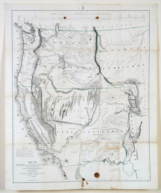
"Map of Oregon and Upper California from the Surveys of John Charles Fremont and Other Authorities…". Drawn by Charles Preuss and published in "Washington City," 1848. Image measures approximately 33" x 26½". Some outline color. From Geographical Memoir upon Upper California. Showing the entire West from Ft. Laramie. Along the top is "Profile of the traveling route from the South Pass of the Rocky Mountains to the Bay of San Francisco." Very good; scattered toning, most concentrated at lower right; several dark spots at upper and lower edges. Ref: Wheat (TM) 559 illus; Goss (NA #77; Schwartz pl. 171.
Estimated Value $800 - 1,200.

 
Realized $510


Go to lot:  


Home | Current Sale | Calendar of Events | Bidding | Consign | About Us | Contact | Archives | Log In

US Coins & Currency | World & Ancient Coins | Manuscripts & Collectibles | Bonded CA Auctioneers No. 3S9543300
11400 W. Olympic Blvd, Suite 800, Los Angeles CA 90064 | 310. 551.2646 ph | 310.551.2626 fx | 800.978.2646 toll free

© 2011 Ira & Larry Goldberg Coins & Collectibles, All Rights Reserved
info@goldbergcoins.com