|
Sale 94
Manuscript & Collectibles Auction
| Lot |
Photo |
Description |
Realized |
Lot 283 |
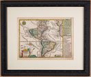 |
Two 18th Century Maps by Schreibner, America & Nord America. Two,maps, each beautiful copper engravings from the 1700s (likely hand-tinted later) by Joh. George Schreibner. One is entitled America the other Nord America. Both measure 7½ x 10" matted and framed to 13 x 16" and quite fine. $300 - 500
View details and enlarged photos
| Unsold |
Lot 284 |
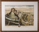 |
Mid-18th Century Engraving, Howarden Castle and Park, Wales. Hawarden Castle and Park, in Flintshire, Five Miles from the City of Chester. "The Seat of Sir John Glynne Baronet," drawn by T. Badeslade, 1740, handcolored, 16¾ x 22 in. (visible); matted and framed to 24 x 29¼ in. Fine. The old Norman castle, located in northeastern Wales, played a role in the struggle for Welsh independence in the late 1200s. Edward I of England finally conquered the area in 1284 and Hawarden Castle was an important English stronghold in the Welsh Marches (border country) during the following years. The castle also played a role in the English Civil War in the mid 1600s. Sir John Glynne (1713-77), 6th baronet, was a Welsh politician and landowner who represented Flintshire in Parliament from 1741 to 1747 and from 1753-77. In 1752, he built a new Hawarden Castle on the grounds of the ruined castle pictured here. $300 - 500
View details and enlarged photo
| Unsold |
Lot 285 |
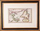 |
Copper Engraving, Map of The Gulf of St. Lawrence ca. 1760s. Copper engraving Carte du Golphe de St Laurent from 1760, Paris 8½ x 14" of the Gulf of St. Lawrence with Newfoundland by Jacques Nicolas.Bellin [1703 - 1772] and in exceptional condition beautifully matted and framed to 18½ x 24" in gilt wood frame. $200 - 400
View details and enlarged photo
| Unsold |
Lot 286 |
 |
Three ca. 18th-19th Century Copper Engraved Maps of Azores, England, and Europe. Three vintage original late 18th century and very early 19th century copper engraved maps. The most striking Angra op Tercera, 19th century map of the Angra op Tercera, showing the city of Angra and portions of the island in the Azores. Incredibly appealing map with over 12 ships illustrated in great detail, the hand-tinting quite exceptional, the map in fine condition. 11½ x 13½" very nicely matted and framed to 18 x 20". The second a map of England, "Le Royaume d'Angleterre divisé selon les sept Royaumnes, ou Heptarchie des Saxons, avec La Principauté de Galles…." published in France by Robert, 18�" x 20". Showing shires and counties, as well as the towns and cities; also part of Scotland and the eastern edge of Ireland. Matted and nicely framed to 20�" x 22" very good to fine. Finally a map by Ortelius with a large ship under full sail, Neptune with trident riding a sea monster, and large title cartouche. The map extends from Rotterdam and Dordecht in the north to Antwerp in the south, and is based on Jacob van Deventer's map of Zeeland from 1547. 16 x 21 and in good condition with evidence of decades old water stains in borders. $400 - 600
View details and enlarged photos
| Realized
$288 |
|
|