
|
Sale 88
The Manuscripts, Collectibles and Space Auction
| Lot |
Photo |
Description |
Realized |
Lot 193 |
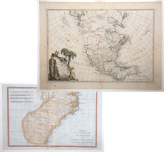 |
2 Vintage Antique Maps of the Southern United States, Late 1700s. Two exceptional antique maps from the late 1700s. The first by Jean Javier, "L'Amerique Septentrionale Divisee in ses Principaux Etats." The entire southwest is titled Nouveau Mexique and the midwest, Louisiane. Directly above N. Albion (California) is a non-existent Mer Ou Baye De L'Quest. From DeLisle's Atlas Modern. 1762. later editions 1771-1783. Measures 12" x 18, on laide paper, hinge mounted in acid free mat, minor foxing and age toning and with four tiny holes in margins otherwise quite fine. Very attractive, full color cartouche with title. The second map by Rigobert Bonne, "Carte de la Partie Sud des Etats Unis De L'Amerique Septentrionale published in 1770-1780s, 8¼" x 12¼" with full margins. This is one of the four most desireable Bonne maps of the early United States depicting the souther part of the newly emerging country. The area shown extends from St. Mary River in southern Georgia to Chesapeake Bay. Towns, forts Indian tribes, rivers and mountains in relief are illustrated. In exceptional condition, printed on laid paper hinge mounted in simple acid free mat.
Estimated Value $400 - 600.
Estate of Alexander White III From the Collection of Alexander White III.
View details and enlarged photo
| Realized
$504 |
Lot 194 |
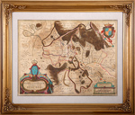 |
Antique Map: The Sovereignty of Sedan and Raucourt and Prevoste of Doncheri. "Le Souverainete de Sedan et de Raucourt et la Prevoste de Doncheri" Antique copper etching. Published by Jodocus junior and brother Heinrich Hondius. Amsterdam, 1632. Recent hand coloring. Verso: Text in French. This map was originally produced as a single sheet map. It was individually sold at Melchior The plate was then used for the Hondius atlas in 1632. Highly decorative map with three Renaissance cartouches and a coat of arms of the city of Sedan and its surrounding. Rivers, mountains, forests are decoratively superelevated. As examined in frame, general age toning, originally folded but displayed flat for years, printed on laid paper, likely recently hand colored and with image 14¾" x 19¾" nicely framed to 22" x 26".
Estimated Value $300 - 500.
Estate of Alexander White III From The Collection of Alexander White III.
View details and enlarged photo
| Realized
$180 |
Lot 195 |
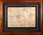 |
Antique Map of Boston "As It Should Be" 1867, E. P. Dutton & Co. Original, antique map of "Boston (as it should be) and the Country Adjacent with proposed Harbor Improvements. Etc." published in 1867 by the storied American printing and publishing house, E.P. Dutton and Company of Boston, Massachusetts. Beautifully colored with the block and stencil method, noting in miles the distances from the State House in Boston. Image size is 17½" x 25" Mat size 27" x 34" and meticulously presented with full museum conservation, handsomely framed in mahogany to 31" x 38". Comes with original COA affixed on verso from Lahaina Print Sellers Ltd. A beautiful piece in excellent condition save for rips in the brown craft paper backing on back of frame. Seller responsible for 3rd Party Shipping.
Estimated Value $500 - 800.
View details and enlarged photo
| Unsold |
Lot 196 |
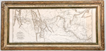 |
Map of Lewis and Clark's Track. An incredible journey of over 8,000 miles presented in "A Map of Lewis and Clark's Track, Across the Western Portion of North America From the Mississippi to the Pacific Ocean; By Order of the Executive of the United States, in 1804, 5 & 6." Copied by Samuel Lewis from the Original Drawing of Wm. Clark. Published in 1814 by Bradford and Inskeep, Philadelphia. The map is tan and measures: 13 x 30½ inches. Light staining along right vertical margin. Handsomely framed to an overall size of 16½ x 34½ inches. The principal objective of Lewis and Clark's Corps of Discovery 1804-06 was the mapping of the West to the Pacific Ocean. Clark's final cartographic achievement was his 1814 engraved map. One of the great maps of all times, it is perhaps the single most influential one of the American West, for it was upon this map that our modern understanding of the topography of that vast areas would evolve. Fine.
Estimated Value $250-UP.
View details and enlarged photo
| Realized
$1,199 |
|
|