
|
Sale 73
The Manuscript, Space & Collectibles Auction
| Lot |
Photo |
Description |
Realized |
Lot 183 |
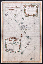 |
Bellin, Jacques Nicolas. Carte Reduite des Isles Antilles…Pour le Service des Vaisseaux du Roi, Paris : [Département de la Marine], 1758. Sheet size: 35½ x 23", hand colored. A very attractive, detailed sea chart on two joined sheets covering the region from the Virgin Islands to Grenada. Lovely decorative title cartouche and inset: "Carte particulière des Isles des Vièrges" within a decorative cartouche; also, two views of the Island of Saint Eustatius in the Dutch Antilles. On very thick paper; minor soiling; one light damp stain at lower edge. An uncommon map. Bellin was the senior hydrographic engineer of the Dépôt de la Marine. He wrote a five-volume treatise on Gulf Navigation in 1749.
Estimated Value $600 - 800
View details and enlarged photo
| Unsold |
Lot 184 |
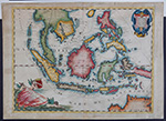 |
Coronelli, Vincenzo. Isole delle Indie, divise in Filippine, Molucche, e della Sonda, Descritte e Dedicate dal P. Coronelli, Cosmografo della Serenissima Republica di Venetia, Venice, 1696. Sheet size: 19½ x 27", hand colored. From Coronelli's rare Atlante Veneto, one of the most decorative and ornate of all 17th Century atlases. A lovely map of Southeast Asia from Burma to Northern Australia showing all the islands closer together than they really are. Decorative title and milage-scale cartouches. Coronelli made globes and was among the foremost Italian mapmakers of his time. Light overall toning; some darkening to borders.
Estimated Value $1,500 - 2,000
View details and enlarged photo
| Realized
$1,050 |
Lot 185 |
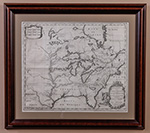 |
Hennepin, Louis P. Carte d'un très grand Pais Nouvellement découvert dans L'Amérique Septentrionale, Entre le Nouveau Mexique et la Mer Glaciale avec le Cours du Grand Fleuve Meshasipi dediée à Gulliaume IIIe ., Leiden, 1704. Uncolored, 14¾ x 17½". A striking example of Hennepin's map of the eastern and midwestern portions of North America, from his Nouvelle Découverte d'un Très Grand Pays. One the earliest and most important depictions of the Great Lakes, Mississippi Valley and Ohio Valley. Although a considerable improvement over earlier maps, the Great Lakes are still oversized, Hudson Bay is too far east and the Mississippi River is too far west, with its mouth in what is present-day Texas (based upon La Salle's report).
Father Louis Hennepin (1626-1705) was a Catholic priest and a missionary of the Franciscan Recollect order. He accompanied René-Robert Cavelier, Sieur de La Salle (1643-1687) on part of his journey down the Mississippi in 1682. An excellent summary of the state of knowledge of North America, at the beginning of the 18th century. Among other things, this map attempts to place into perspective Hennepin's mapping of the Great Lakes and the Mississippi River. Karpinski noted that Hennepin's delineations of Lakes Superior, Michigan and Huron are remarkable improvements upon the Sanson maps. Hennepin first brought the attention of the world to Niagara Falls and Saint Anthony Falls. In 1683, he published his book, "A New Discovery" about Niagara Falls.
Estimated Value $1,500 - 2,000
View details and enlarged photo
| Realized
$1,661 |
Lot 186 |
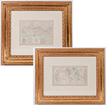 |
Johnson's World. Showing the Lines of Equal Magnetic Declination and the Circulation of the Winds and the Course of Stor, Two thematic world maps drawn by Professor A. Guyot, c.1858, and published in the rare 1870 edition of A. J. Johnson's Atlas of the World. The first map, "Johnson's World. Showing the Lines of Equal Magnetic Declination," is 5¾ x 10", hand-colored, "Entered according to Act of Congress in the Year 1870 by A. J. Johnson in the Clerk's Office of the District Court of the United States for the Southern District of New York." The second map, "Showing the Circulation of the Winds and the Course of Storms," is 6¼ x 8½" and "Entered according to Act of Congress in the Year 1874 by A. J. Johnson in the Office of the Librarian of Congress, at Washington." Attractively framed to 16 x 20" and 16 x 18".
Estimated Value $200 - 300
View details and enlarged photo
| Realized
$240 |
Lot 187 |
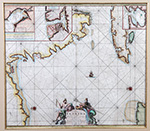 |
van Keulen, Johannes. Pas kaart van de Boght van Florida Met de Canaal Tusschen Florida en Cuba ., Amsterdam, c. 1684-86, 20 x 23", hand colored. Matted and framed to an overall size of 31½ x 34¼". A sea chart of Florida and the Gulf Coast, extending from the Fort Lauderdale area to the area around Appalachiola Bay and including most of Cuba and the tip of the Yucatan. Insets of three Cuban harbors: Havana, Mantanzas and Baja Hondo (possibly Golfo de Guanahacabibes).
This handsome and important map was published in van Keulen's monumental five-volume sea atlas, the Zee-Fakkel (1684-1689) which continued to be printed up to 1800 and was published in over 120 editions. Part IV of the atlas, where this map appeared, was devoted to America, and in its separately published form, was the first sea atlas specifically devoted to the New World. The decorative title cartouche features Neptune, god of the sea, and one of the gods of the winds, possibly Zephir. Burden The Mapping of North America II, 591, state 2.
Estimated Value $3,000 - 4,000
View details and enlarged photo
| Realized
$2,400 |
|
|