|
Sale 71
The Manuscripts, Collectibles & Space Auction
| The Hunter Collection of Antique Maps |
| |
| |
| Lot |
Photo |
Description |
Realized |
Lot 21 |
 |
Basle, Sebastian Munster. Sea Monsters, Basle, c. 1544. "Meerwunder und seltzame Thier wie die in den Mitnächtigen Ländern gefunden werden," 12¼ x 15¼". Two-page woodcut of sea monsters, which is a compilation of medieval monsters used by cartographers and engravers. From Sebastion Munster's epic Cosmographia (Universal Cosmography), which explored disciplines such as natural science, astronomy, geography, history and folklore.The Cosmographia was the most read book in 16th century Germany after the Bible. German text on verso. Two pieces of tape remnant at top verso from previous framing and light toning in margins.
Estimated Value $300 - 500.
View details and enlarged photo
| Realized
$750 |
Lot 22 |
 |
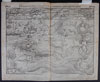
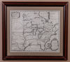
Bellin, Jacques Nicolas. Carte de la Virginie, de la Baye Chesapeack, et Pays Voisins. "Pour servir a l'Histoire Générale des Voyages," handcolored, 8 x 11 7/8" (plate size). Engraved by Bellin (1702-1772), director of the Dépot de la Marine in Paris and published in Prévost's L'Histoire Générale des Voyages in 1757. Early map depicting Chesapeake Bay with parts of Virginia, Maryland, Delaware and New Jersey. The Severn River, the harbor of Annapolis, the York River with Hampton, Gloucester, and Norfolk, and the entrance to Delaware Bay at Cape May and Cape Henlopen are shown, as well as all harbors along the coast and major towns and villages inland. The decorative title cartouche at lower right has scrolls, leaves & flowers. Matted and framed to an overall size of 16¾ x 20".
Estimated Value $400 - 600.
View details and enlarged photo
| Realized
$480 |
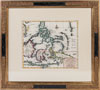
Lot 23 |
 |
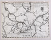
Bellin, Jacques Nicolas. Carte Reduite des Isles Antilles…Pour le Service des Vaisseaux du Roi. Paris : [Département de la Marine], 1758. Sheet size: 35½ x 23", hand colored. A very attractive, detailed sea chart on two joined sheets covering the region from the Virgin Islands to Grenada. Lovely decorative title cartouche and inset: "Carte particulière des Isles des Vièrges" within a decorative cartouche; also, two views of the Island of Saint Eustatius in the Dutch Antilles. On very thick paper; minor soiling; one light damp stain at lower edge. An uncommon map. Bellin was the senior hydrographic engineer of the Dépôt de la Marine. He wrote a five-volume treatise on Gulf Navigation in 1749.
Estimated Value $800 - 1,000.
View details and enlarged photo
| Unsold |
Lot 24 |
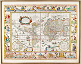 |
Blaeu, G. Nova Totius Terrarum Orbis Geographica Ac Hydrographica Tabulac. Amsterdam, c. 1635. Handcolored, 16 1/8 x 21½", matted to 25 x 36¾". Shirley describes this world map as a "classic single-sheet world map on Mercator's projection… celebrated as one of the supreme examples of the map maker's art." Signed by engraver Josua van den Ende in the lower right corner. Lovely border decorations include allegorical depictions of the sun and the moon and the known five planets - Mercury, Venus, Mars, Jupiter and Saturn--along the top. Down the left side are four panels illustrating the elements (Fire, Water, Air and Earth), and on the right side are the four seasons. Along the bottom are seven vignettes showing the seven ancient wonders of the world: the Hanging Gardens of Babylon, the Colossus over the harbour at Rhodos, the Pyramids, the Mausoleum of Halicarnassus at Caria, the Temple of Diane, the Statue of Jupiter, and the conical lighthouse of Alexandria. (R. Shirley, The Mapping of the World, Entry 255). Decorative cartouches for the title, dedication and explanation, two spheres for the north and south poles, compass roses and numerous ships and sea monsters. This exceptionally beautifully map appeared in the Blaeu Atlas from 1630 until 1658.
Estimated Value $6,000 - 8,000.
View details and enlarged photo
| Realized
$8,610 |
Lot 25 |
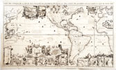 |
Chatelain, Henri Abraham (1684-1743). Carte Très Curieuse De La Mer Du Sud. Mais aussy sur les principaux pays de l'Amerique… avec les noms & la route des voyageurs par qui la découverte en a été faite. (Amsterdam, 1719). Uncolored, 32½ x 56". One map on 4 sheets, this spectacular map of the Pacific and Americas, was published in the sixth volume of Chatelain's Atlas Historique, which was devoted to the Americas. It shows America in the middle (with California as an island), Europe on one side and the Pacific with Japan and China on the other.
There are more than 35 insets and vignettes. Nine medallions at the top center portray the explorers Columbus, Vespucci, Magellan, Drake, Dampier, Le Maire, Schouten, Olivier van Noort and L'Hermite, and the tracks of their voyages are marked on the map. The marginal vignettes range from narrative scenes representing colonial economies based on beaver, cod, and sugar to geographic insets of locations such as the Mississippi delta, Niagara Falls,and the Cape of Good Hope, as well as towns such as Panama, Acapulco, Lima, Baldive La Ville de Mexique, La Conception, Rio de la Plata, La Havane, St. Sebastien, and Vera Cruz.
"One of the most elaborately engraved maps of the Western Hemisphere ever produced." (Schwartz & Ehrenberg, p.142).
Tooley, California as an Island 80. Mc Laughlin, 190.
Estimated Value $10,000 - 15,000.
View details and enlarged photo
| Realized
$9,300 |
Lot 26 |
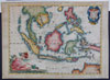 |
Coronelli, Vincenzo. Isole delle Indie, divise in Filippine, Molucche, e della Sonda. Descritte e Dedicate dal P. Coronelli, Cosmografo della Serenissima Republica di Venetia, Venice, 1696. Sheet size: 19½ x 27", hand colored. From Coronelli's rare Atlante Veneto, one of the most decorative and ornate of all 17th Century atlases. A lovely map of Southeast Asia from Burma to Northern Australia showing all the islands closer together than they really are. Decorative title and milage-scale cartouches. Coronelli made globes and was among the foremost Italian mapmakers of his time. Light overall toning; some darkening to borders.
Estimated Value $2,000 - 3,000.
View details and enlarged photo
| Unsold |
Lot 27 |
 |
de Bry, Theodore. Occidentalis Americae partis, vel earum Regionum quas Christophorus Columbus…. Leiden, 1594. Uncolored. 13 x 17". Published in Grands Voyages, Part IV. This seminal, exceedingly rare map of Florida, the Gulf Coast, and the Caribbean represents the geographical information collected over 15 years by explorers in the region, specifically the region traveled by Girolamo Benzoni between the years 1541 and 1556. Centered on the disproportionately large islands of the Caribbean, the map also provides an early delineation of Florida derived from Jacques Le Moyne de Morgues and is one of the earliest maps to detail northern South America. The islands of the Bahamas are too large and placed considerably north of their true location. Various legends on the map mark the four voyages of Columbus and make an early mention of the Gulf Stream. De Bry's engraving skill and style are seen in the elaborate cartouche, coat of arms, compass rose, sea monsters, Spanish galleon and intricate border. A lovely, charming map.
Estimated Value $5,000 - 7,500.
View details and enlarged photo
| Realized
$2,400 |
Lot 28 |
 |
Hennepin, Louis P. Carte d'un très grand Pais Nouvellement découvert dans L'Amérique Septentrionale. Entre le Nouveau Mexique et la Mer Glaciale avec le Cours du Grand Fleuve Meshasipi dediée à Gulliaume IIIe ., Leiden, 1704. Uncolored, 14¾ x 17½". A striking example of Hennepin's map of the eastern and midwestern portions of North America, from his Nouvelle Découverte d'un Très Grand Pays. One the earliest and most important depictions of the Great Lakes, Mississippi Valley and Ohio Valley. Although a considerable improvement over earlier maps, the Great Lakes are still oversized, Hudson Bay is too far east and the Mississippi River is too far west, with its mouth in what is present-day Texas (based upon La Salle's report).
Father Louis Hennepin (1626-1705) was a Catholic priest and a missionary of the Franciscan Recollect order. He accompanied René-Robert Cavelier, Sieur de La Salle (1643-1687) on part of his journey down the Mississippi in 1682. An excellent summary of the state of knowledge of North America, at the beginning of the 18th century. Among other things, this map attempts to place into perspective Hennepin's mapping of the Great Lakes and the Mississippi River. Karpinski noted that Hennepin's delineations of Lakes Superior, Michigan and Huron are remarkable improvements upon the Sanson maps. Hennepin first brought the attention of the world to Niagara Falls and Saint Anthony Falls. In 1683, he published his book, "A New Discovery" about Niagara Falls.
Estimated Value $2,000 - 3,000.
View details and enlarged photo
| Unsold |
Lot 29 |
|
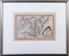
Johnson's World. Showing the Lines of Equal Magnetic Declination and the Circulation of the Winds and the Course of Stor. Two thematic world maps drawn by Professor A. Guyot, c.1858, and published in the rare 1870 edition of A. J. Johnson's Atlas of the World. The first map, "Johnson's World. Showing the Lines of Equal Magnetic Declination," is 5¾ x 10", hand-colored, "Entered according to Act of Congress in the Year 1870 by A. J. Johnson in the Clerk's Office of the District Court of the United States for the Southern District of New York." The second map, "Showing the Circulation of the Winds and the Course of Storms," is 6¼ x 8½" and "Entered according to Act of Congress in the Year 1874 by A. J. Johnson in the Office of the Librarian of Congress, at Washington." Attractively framed to 16 x 20" and 16 x 18".
Estimated Value $250 - 300.
View details
| Unsold |
Lot 30 |
 |
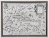
Lahontan, Louis. Carte Générale de Canada Dediée au Roy de Danemark. Par son très humble et très obéissant et très fidèle serviteur Lahontan (The Hague, Charles Delo, 1706). 16¼ x 21¾", uncolored. From Voyages du Baron de La Hontan dans l'Amérique septentrionale : qui contiennent une relation des différens peuples qui y habitent; la nature de leur gouvernement, leur commerce, leurs coûtumes, leur religion, & leur manière de faire la guerre; l'intérêt des François & des Anglois dans le commerce qu'ils font avec ces nations; l'avantage que l'Angleterre peut retirer de ce païs, étant en guerre avec la France. Binder's instructions at upper right: "Tom: 2. Pag: 1."
Excellent illustration of the regional river systems and placement of American Indian villages and French forts throughout the region. The depiction of the Great Lakes is primitive but still superior to a number of later maps. The English colonies in New England are identified as New York (Nouvelle York), Manhattan (Manate), Montreal (Monreal), Quebec (Kebek) and Boston (Baston). The Hudson River is identified as the R. de Monate. The future site of Chicago is identified as Chegakou or Portage de v des Illinois.
Louis Armand de Lom d'Arce, Baron de Lahontan (1666-1715) served in the French military in Canada where he traveled extensively in the Wisconsin, Minnesota and the upper Mississippi Valley. His claim of discovering a "Longue River" in the upper Mississippi valley, flowing to high mountains, with a great body of salt water beyond the mountains, was accepted and incorporated by most of the major mapmakers of the period. His often fanciful Nouveaux voyages dans l'Amérique septentrionale (1703) was very popular.
Estimated Value $5,000 - 6,000.
View details and enlarged photo
| Realized
$2,160 |
Lot 31 |
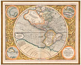 |
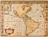
Mercator. America sive India Nova ad magnae Gerardi Mercatoris avi universalis imitationem incompendium redacta. Per Michaelem Mercatorem, Duysburgensem. Flanders, c. 1613-1630. Copper engraving, hand-colored, 14½ x 18". Matted to 25 x 36½". Beautiful map of the Western Hemisphere, surrounded by four roundels containing the map's title (lower right) and three insets of individual areas of North America: the western shores of the Gulf of Mexico, Cuba and Florida, and Hispaniola and Puerto Rico. This Latin edition is the only map known to have been made by Michael Mercator, grandson of Gerardus Mercator. The depiction of a Northwest Passage illustrates the contemporary belief that a direct route to the East existed. Michael Mercator (c.1567-1600), belonged to arguably the most famous family of mapmakers. Jodocus Hondius bought Mercator's plates in 1604 and continued to issue this map. (Burden 87).
Estimated Value $3,000 - 5,000.
View details and enlarged photo
| Realized
$1,860 |
Lot 32 |
 |
Moll, Herman. A Map of the West-Indies or the Islands of America in the North Sea, c. 1715. with ye adjacent Countries; explaining what belongs to Spain, England, France, Holland &c Also ye Trade Winds and ye several Tracts made by ye Galeons and Flota from Place to Place (London, c. 1715). Sheet size: 25 x 42". Outline coloring. Dedicated to William Paterson, founder of the Bank of England.
A detailed map charting part of the West Indies, the Caribbean, the Gulf of Mexico, Mexico, and the Spanish Main, with insets of Vera Cruz, Havana, Porto Bella, St. Augustine, and Cartagena, plus a lovely 13½" inset of Mexico City with an index identifying many of the buildings in that city. The map has been called a guide for English pirates and privateers because it offers detailed information on the path taken by the Spanish flotilla taking treasure on at Veracruz (from the silver mines of Potosí) to Spanish ports in Europe; for example, Moll notes "At Cartagena, the Gallions usually stay 60 days, and thence go to Portobel where they lye 30 days…they sail from Havana [where he notes 'a High Tower where is always watch kept'] to meet ye Flota, which is a small number of ships that go to Vera Cruz to take in ye Effects of that Country." From Veracruz he shows the route of the ships "occasioned by ye Trade Winds." In the Gulf of Mexico, he gives instructions on determining how far a ship is from shore, and from Havana, he notes that the Gallions and Flota usually join there and the whole Armada sails for Spain through the gulf between Florida and the Bahamas.
Very good. Printed on two sheets joined by the original publisher. Common minor wear along original centerfold. Border has some light soiling and small closed edge tears. A beautiful and important map.
Estimated Value $4,000 - 6,000.
View details and enlarged photo
| Realized
$2,160 |
Lot 33 |
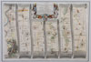 |
Ogilvy, John. The Road from London to St. Davids in com: Pembroke. London, 1675. 12¼ x 17¾", hand-colored. A strip map, from the first printed British road atlas, Britannia, published in 1675, which set the standard for road maps. Matted and framed to an overall size of 19¾ x 25". With a decorative title cartouche and the British royal arms on a shield. Ogilvy (1600-1676), a Scottish translator, was named as cosmographer and geographic printer for His Majesty, Charles II, in 1674.
Estimated Value $400 - 600.
View details and enlarged photo
| Realized
$510 |
Lot 34 |
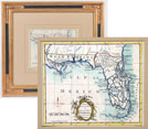 |
Procter, J. A New and Accurate Map of East and West Florida, Drawn from the best Authorities. London, c. 1760s. 7½ x 8¾", engraved by J. Procter. Hand-colored. Similar to Kitchin's map in the March 1765 issue of The London Magazine but without the magazine's title above the top neat line and the title cartouche is at bottom center, rather than in the lower left corner. Handsomely matted and framed to an overall size of 16½ x 18".
A colonial-era portrayal of East and West Florida, whose boundary is marked by the Apalachicola River. West Florida extends to the Mississippi and much of East Florida appears as islands separated by numerous rivers. The Florida Keys are identified as Cayos de los Martyres and the Tampa area is called "Tampa Bahia" (Tampa Bay). Because Florida remained loyal to Spain during the American Revolution, it was returned to Spain (an ally of the American colonies) by the Second Treaty of Paris in 1783. It became the Territory of Florida in 1821 and the 27th state in 1845.
Estimated Value $500 - 600.
View details and enlarged photo
| Realized
$480 |
Lot 35 |
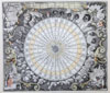 |
Seutter, Georg Mattheus. Tabula Anemograpica seu Pyxis Nautica, vulgo Compass. Charte. Ventorum Noia septem linguis graeca. Augsburg, c. 1730. 19½ x 22½", hand colored. Matted and framed to 33 x 36". Based on Janson's 1650 map but Seutter added figures in each corner, representing the four seasons. This map depicts an anemographic, or compass rose, and represents a transitional point in the perception of direction, from the wind rose to the compass rose. Surrounding the sphere are winds personified by a figure bearing the racial characteristics associated with the region or direction represented. Bearded Germans or Scandinavians are in the upper left quadrant, representing north. At upper right, representing east, are beardless, dark-skinned faces. At lower left and right, representing west and south, are figures which probably represent native Americans and Greeks. Thirty-two winds and many wind systems are shown. Each of the winds is identified in Greek, Latin, Italian, Spanish, French, Dutch and German. Anemographic charts were valuable reference tools.
Estimated Value $800 - 1,200.
View details and enlarged photo
| Realized
$660 |
Lot 36 |
 |
Speed, John. America with those parts in that unknowne worlde both people and manner of buildings. "Discribed and inlarged by J.S. Ano. 1626." Engraved by Abraham Goos, published by Thomas Bassett and Richard Chiswel [1676], the map appeared in Speed's atlas "Prospect of the World." Hand colored, 15 1/2 x 20 1/5". Attractively matted and framed to 21½ x 26".
One of the most decorative and interesting maps of North and South America from the seventeenth century, with superb decorative and historical vignettes. This is Speed's most famous map, with views of eight cities in the Americas, as well as ten depictions of indigenous peoples from the various regions, including the northern, middle and southern parts of the eastern coast of North America. An inset map shows Greenland, Baffin's Bay and Iceland. Considerable detail is shown in South and Central America and the eastern parts of North America, including indications of the Chesapeake, Delaware and Hudson Bays. This map is most famous, however, for its depiction of California as an island; it is the first atlas map to depict this misconception, which was copied long thereafter. The Atlantic and Pacific Oceans are filled with delightful ships, sea monsters and flying fish. Burden, 217.
Estimated Value $6,000 - 8,000.
View details and enlarged photo
| Realized
$4,560 |
Lot 37 |
 |
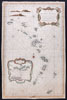
Tirion, Isaac. Nuova, et Accurata Carta dell'Isole Filippine, Ladrones, e Moluccos, o Isole delle Speziarie come anco C. Amsterdam, c. 1740. 11 x 12¾", hand-colored. From the second edition in Italian (first edition, 1734) of Thomas Salmon's work, Modern History: or, the present state of all Nations. entitled Lo Stato Presente… published in Venice from 1740-1762. Just above neat line at upper right is " I. 2. p.167." Matted and framed to an overall size of 21½ x 22½".
In Volume I of Salmon's work, a description of the contents of the first ten volumes is given ("Disegno dell'opera proposto dallo Stampatore"), including a statement about the maps, "… le quali Carte sono intagliate sopra gli Originali di Amsterdam formati so le ultime osservazioni del più accreditato fra' Geografi Moderni il Signor de La Isle…."; so although Tirion first "gave light to" ["data in luce"] the maps in Salmon's work, de L' Isle is given geographic credit. Tirion's own atlas was issued in Amsterdam in 1744.
Estimated Value $600 - 800.
View details and enlarged photo
| Realized
$300 |
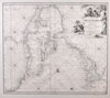
Lot 38 |
 |
van Keulen, Johannes. Pas kaart van de Boght van Florida Met de Canaal Tusschen Florida en Cuba . Amsterdam, c. 1684-86, 20 x 23", hand colored. Matted and framed to an overall size of 31½ x 34¼". A sea chart of Florida and the Gulf Coast, extending from the Fort Lauderdale area to the area around Appalachiola Bay and including most of Cuba and the tip of the Yucatan. Insets of three Cuban harbors: Havana, Mantanzas and Baja Hondo (possibly Golfo de Guanahacabibes).
This handsome and important map was published in van Keulen's monumental five-volume sea atlas, the Zee-Fakkel (1684-1689) which continued to be printed up to 1800 and was published in over 120 editions. Part IV of the atlas, where this map appeared, was devoted to America, and in its separately published form, was the first sea atlas specifically devoted to the New World. The decorative title cartouche features Neptune, god of the sea, and one of the gods of the winds, possibly Zephir. Burden The Mapping of North America II, 591, state 2.
Estimated Value $4,000 - 6,000.
View details and enlarged photo
| Unsold |
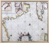
Lot 39 |
 |
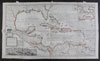
van Keulen, Johannes. Pas Kaart Van West Indien Behelsende soo Deszelffs Vaste Kusten als d'Onder behoorende Eylanden a. Amsterdam, c. 1680. 20 x 23", uncolored. Showing the East and Gulf Coasts of the United States. One of the most decorative and desirable sea charts of the 17th Century. From Canada to Venezuela, the coastline of the Western Atlantic Ocean is shown with hundreds of place names. Cuba and Florida are in the center of the map, and the "South Sea" (De Zuyd Zee) is at top left. Lovely decorative title cartouche; the waters below "Barmuda" hold a sailing ship and a wind rose. The van Keulen family was known for its sea charts. They published a volume of sea charts, the Zee-Fakkel, in 1681-82, which continued to be printed up to 1800 and was published in over 120 editions.
Estimated Value $2,500 - 3,500.
View details and enlarged photo
| Realized
$1,440 |
|
|