
|
Sale 68
The June 30th Manuscript and Collectibles Auction
| Lot |
Photo |
Description |
Realized |
Lot 73 |
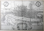 |
18th Century Engraving of London. "A Plan of London Westm.r and Southward n.th ye Riv.r Thames as they were survey'd and publisb't by authority toward ye latter end of ye Raign of Queen Elizabeth or about ye year of our Lord 1600…." 13 x 19 in. Title cartouche at bottom center. Latin text in boxes at lower right and left. At upper right: "page 1, Introduc.n." Some fold wear; closed tear from left edge center extending into decorative cartouche at upper left. Matted and framed to 17¾ x 20½ in.
The original map was published in 1572 for the 'Civitates Orbis Terrarum', the first series of printed town plans, with the title 'Londinum Feracissimi Angliae Regni Metropolis' in a cartouche at top center. Jansson re-issued the plate in 1657 and added a new title 'Londinium Vulgo London' in a cartouche at bottom center where four figures in Elizabethan dress had been.
Estimated Value $300 - 500.
View details and enlarged photo
| Realized
$300 |
Lot 74 |
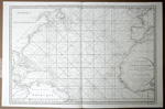 |
Carte Générale De L'Océan Atlantique ou Occidental, Dressé au Dépot général des Cartes Plans et Journaux de la Marine, 1. Published by Dépot Générale de la Marine, by order of the Ministry for the Service of French Vessels, 24 x 35½ in. Copper-engraved chart showing the Atlantic from the mouth of the Amazon in the south to Labrador in the north, with corresponding latitudes in the east. Much coastal detail and many place named. The North American coast, including the United States, is shown. Nice and clean.
Estimated Value $300 - 400.
View details and enlarged photo
| Unsold |
Lot 75 |
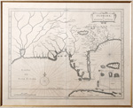 |
Florida et Regiones Vicinae. By Joannes De Laet, Leiden, 1630. 14 x 11 inches. Matted to 21½ x 21 in. Probably the finest 17th-century description of America. The map was almost certainly engraved by Hessel Gerritsz, based upon the work of Claesz in 1602 and Jacques Le Moyne's map of Florida, with nomenclature drrawn from Chaves map of 1584. One of the earliest obtainable maps of the Southeastern United States.
References: Burden 231.
Estimated Value $1,800 - 2,200.
View details and enlarged photo
| Unsold |
Lot 76 |
 |
John Speed Map of Virginia And Maryland. By John Speed, London, 1676. 19½ x 15 inches. Hand colored map of Virginia and Maryland, engraved by Francis Lamb. It first appeared in the enlarged edition of Speed's Atlas in 1676.
This is one of the first maps to incorporate the information from Augustine Herrman' s "Virginia and Maryland As it is Planted and Inhabited this present Year 1670 Surveyed and Exactly Drawne by the Only Labour & Endeavour of Augustin Herrman Boehemiensis." An English-text description of Maryland and Virginia appears on the verso.
The majority of the cartographic information derives from John Smith's earlier map of Virginia. Speed's four maps of the English colonies in America were the first "new" set of printed maps of the Colonies to appear in a commercial atlas after the English took control of the territory which became the British Colonies in North America and later the first 13 states.
Estimated Value $4,000 - 5,000.
View details and enlarged photo
| Realized
$3,600 |
Lot 77 |
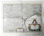 |
La Partie Méridionale Du Languedoc - by Janson. Amsterdam, 17th century, 14¾ x 19 From an atlas, text in Latin, hand-colored. Lovely decorative cartouche. Small cartouche in French with Latin names states that it was printed by Joannes Janssonius and is sold at Paris by Melchior Tavernier, living near the palace. Light soiling; vertical fold has split at center and older tape repairs at top and bottom on verso; a couple of closed repairs at top edge; some paper loss along blank lower margin and tiny chips to other margins. Still a lovely map.
Estimated Value $400 - 600.
View details and enlarged photo
| Unsold |
Lot 78 |
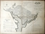 |
"Plan of the City of Washington in the Territory of Columbia. Ceded by the states of Virginia and Maryland to the United States of America, and by them established as the seat of their government, after the year MDCCC." Engraved by Thackara and Vallance, Philadelphia: 1792. 23 x 30½ in. Closed edge tears; backed with japan paper; some soiling. An early issue.
When the location of the site of the new nation's capital was being debated, the northern states refused to accept its location in the South and vice versa. A compromise was reached between Alexander Hamilton and James Madison that in exchange for the Federal Government's assuming states' debts incurred during the Revolutionary War (wanted by Alexander Hamilton) that the new capital should be in the South. The Residence Act of 1790 was passed, which established that the capital of the United States would be located at a site along the Potomac River. The Act, which gave President George Washington the authority to choose the site, provided for a district not more than 10 miles square along the Potomac River "at some place between the mouths of the Eastern Branch and the Connogocheague."
French artist and engineer Pierre L'Enfant was hired to develop a plan for the capital city but proved to be so difficult that Washington fired him in 1792. He engaged Andrew Ellicott, who had conducted the topographical survey of the area. Ellicott used L'Enfant's design, based on the European model of broad avenues and large public squares, and used to dramatic effect the city's setting along the Potomac River. In order to expedite the sale of land in the as-yet-unbuilt capital, manuscript plans were sent to Thackara & Vallance in Philadelphia and Samuel Blodget, Jr. in Boston to be engraved and published.
Estimated Value $3,000 - 5,000.
View details and enlarged photo
| Realized
$2,640 |
Lot 79 |
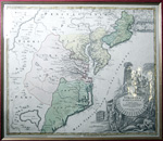 |
Virginia Marylandia et Carolina In America Septentrionali Britannorum industria excultae…. By Johann Baptist Homann (1664-1725), c. 1715, 19¾ x 23½ inches. Covering from New York City and Long Island south along the Atlantic Cost as far as modern day Georgia, and as far west as Lake Erie. Elaborate title cartouche shows the map's title and Homann's Privilege centered on an enormous scallop shell and features a number of stylized American Indians trading with European merchants. The wealth of the region is expressed by an abundance of fish, game, and other trade products. A large alligator curls around the scallop shell. This map appeared in various Homann atlases from about 1714 to 1730.
Homann drew this map in support of Virginia Lieutenant-Governor Alexander Spotswood's plan to encourage German immigrants to settle the interior of Virginia with German immigrants. This is the first mapping of Germantown Teutsche Statt on the Rappahanock River and Fort Christanna on the Makharing River. Fort Christanna, which was built in 1714 as a defense against the Indians, also served as the the headquarters of the Virginia Indian Company, which traded with the Indians in the interior. The map includes various cartographic inaccuracies, the most notable of these is the inclusion of Apalache Lacus. This fictional lake, the source of the May River, appeared on maps of this region since the mid 16th century Le Moyne-De Bry map and was popularized by Mercator and Hondius in 1606. It would remain on maps well into the mid 18th century.
Estimated Value $750 - 1,000.
View details and enlarged photo
| Realized
$750 |
|
|