
|
Sale 64
| Lot |
Photo |
Description |
Realized |
Lot 451 |
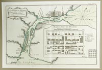 |
First Printed Map of Detroit, c. 1764. La Rivière du Détroit Depuis le Lac Sainte Claire jusqu'au Lac Erié. Engraved for Jacques-Nicolas Bellin (1703-72) after Ensign Gaspard-Joseph Chaussegros de Léry, 8¼ x 12½ in. (20.7 x 31.6 cm.). Date depicted: 1749. Published in Jacques-Nicolas Bellin, Le Petit Atlas Maritime (5 vols., Paris, 1764), vol. 1, map 12 (at upper right: "Tome I. No. 12"). A plan of the fort of Detroit designates the Commandant's quarters, the guardhouse, the church, the powder magazine, and the quarters of the chaplain. Matted to 14½ x 18½ in. Accompanied by an 1831 "Plat of the city of Detroit as laid out by the Govr. and Judges," 18¼ x 11½ in.
Estimated Value $2,400 - 2,800.
View details and enlarged photo
| Unsold |
Lot 452 |
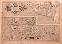 |
Ortelius Map of Cuba and Western Mexico. Copper-engraved map by Abraham Ortelius (1527-1598) with: Culiacanae, Americae Regionis, Descriptio and Hispaniolae, Cubae, Aliarumque Insularum Circumiacientium, Delineatio on the same sheet, uncolored, 14 x 19¼ in., c. 1600. From Ortelius' atlas, Theatrum Orbis Terrarum, first printed in 1579. The top half shows detail along the western coast of Mexico; the bottom half shows Cuba, Hispaniola, the Antilles, Bahamas, and the tip of Florida, and is apparently the first printed map to focus on the West Indies. Some dampstaining, primarily visible in margins; small crease at upper left. With three lovely decorative cartouches and two ships. Very good.
Estimated Value $600 - 800.
View details and enlarged photo
| Realized
$519 |
Lot 453 |
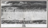 |
Plan of the Camp at Cox-heath 1779 by Isaac Jehner. London, 1779. 14 x 24 in., framed to 20½ x 30¾ in. A detailed map of the British camp at Coxheath, which was a major army camp in Kent, England during the 18th century. In 1778 and 79, the camp held some 17,000 troops, as well as large numbers of civilians. It was visited in 1778 by King George III and Queen Charlotte. The map is fine; frame has some rust marks. Jehner (1750-1818) was an English mezzotint engraver who introduced the art of silver plating into England; he also executed portraits in crayon, watercolor and oil and painted on silk.
Estimated Value $300 - 400.
View details and enlarged photo
| Realized
$2,360 |
Lot 454 |
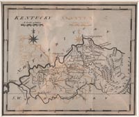 |
"Kentucky" by Joseph T. Scott, 1795. From United States Gazeteer, First state, 6 x 7¼ inches, Philadelphia. Very good; overall toning and off-setting; folds as issued. Wheat & Brun: 643. One of the earliest maps of Kentucky, from the first American gazetteer. Much detail of rivers, counties, roads, and towns, not long after Kentucky's admission as a state (1792). Note the spelling of "Linocln" county. An interesting and desirable map.
Estimated Value $300 - 400.
View details and enlarged photo
| Realized
$228 |
Lot 455 |
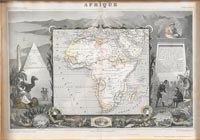 |
Afrique, engraved by Laguillermie. Color outline, 13 x 18½ in.; matted and framed to 23 x 28 in. Published by Lemercier at A. Combette, Paris (1856). From Atlas Universel Illustré. Geography and statistics by V. Levasseur. Illustrated by Raimond Bonheur, painter. Steel engravings in the wide margins around the map (which is 8 x 8¾ in.) showing local people in native dress, towns, products, landscapes, etc. Roads, towns, and cities are marked, as well as French colonies in Africa and the major tribal kingdoms. Light toning, else Fine. Very decorative.
Estimated Value $250 - 300.
View details and enlarged photo
| Realized
$295 |
Lot 456 |
 |
The Tenth Olympic Games Los Angeles…July 30-Aug. 14 '32. "A Complete Map of Los Angeles Area and Guide to Olympic Games," 21 x 28¾ inches. With explanatory legend for the various events and their venues. Cities along the coast of California are pictured at left, right, and bottom margins; the number of miles from Los Angeles is given for each city. Light toning, else Fine. Double framed to 21 x 28½ inches. These were given out by the Union Oil Company.
Estimated Value $250 - 350.
View details and enlarged photo
| Realized
$180 |
Lot 457 |
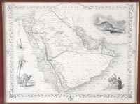 |
Arabia. 10¼ x 13¾ in. Matted and framed to 17 x 20 in. Color outline. Map drawn and engraved by J. Rapkin; surrounding illustrations by H. Warren and engraved by J. Rogers. Published by J. & F. Tallis London & New York (1852). Vignetts of Mount Sinai, two Arab men, a camel by a palm tree, and Arab women carrying containers on their heads. Decorative border. One small tear at lower edge, not touching decorative border.
Estimated Value $100 - 125.
View details and enlarged photo
| Realized
$118 |
|
|