
|
Sale 38
Manuscript and Collectibles Auction
| Lot |
Photo |
Description |
Realized |
Lot 550 |
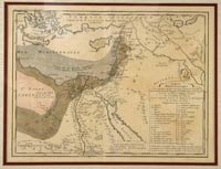 |
1751 Map of Egypt, Palestine, and Syria. Hand-tinted map entitled "Carte Minéralogique Sur la Nature du Terrein…de "Egypte, de la Palestine et de la Syrie Dressée en 1751 par Philippe Buache," 11¼x15". Fine; center fold. Matted to 16¾x20¼" and ready for framing. Areas with various types of mineral are identified, as well as hot springs, sulphuric fountains, lead, marble, granite, alabaster, etc.
Estimated Value $200 - 300.
View details and enlarged photo
| Unsold |
Lot 551 |
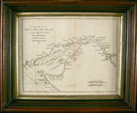 |
1776 Chart of Delaware Bay and River. Printing of Fisher's 1776 original chart, taken from the July 1779 issue of Gentleman's Magazine (present), 8x10", London. Very good; light soiling. It is rare to find this map. It has been framed to an overall size of 10¼x12½".
Estimated Value $200 - 300.
View details and enlarged photo
| Realized
$120 |
Lot 552 |
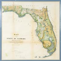 |
1857 Color Map of Florida. Oversized hand-tinted map of the state of Florida, 24½x24½", showing the progress of the surveys that accompanied the Surveyor General's annual report for 1857 (Washington). Light toning; some stress along the fold lines. Matted to 28½x27½" and ready for framing. A lovely map.
Estimated Value $300 - 500.
View details and enlarged photo
| Realized
$288 |
Lot 553 |
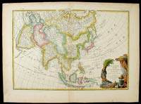 |
(Asia) Beautiful Janvier 18th Century Map of Asia, with a bit of Alaska? "L'Asie divisee En Ses Principaux Etats par le Sr. Janvier, Geographe, A Paris." Ca. 1760s, 12 1/4" high x 17 5/8" wide copperplate engraving with original outline color and a striking fully colored cartouche in an exotic far eastern motif. This handsomely rendered map by Jean Janvier, covers from the western Mediterranean to Kamchatka in the north, and from the Red Sea and horn of Africa to the Philippines and Indonesia in the south, and all else between. A shadowy presence in the Bering Sea hints at the Alaskan coast with the caption "Terre vue par (land seen by) Tchiricoive et DeLisle en 1741." There is very minor soiling and age tone otherwise very good condition. Now scarce.
Estimated Value $800 - 1,000.
View details and enlarged photo
| Unsold |
Lot 554 |
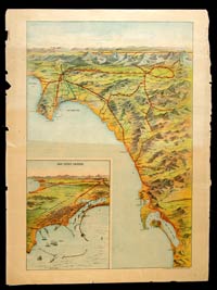 |
c. 1900 Bird's Eye View of Southern California. By H.S. Crocker Co, Los Angeles, 21" x 14", on a 23¼" x 17¼" sheet, showing the "Tehachapy" Mountains in the north down past Tiajuana ("Tia Juana") Mexico in the south, with 9¼" x 7" inset of San Pedro Harbor. A projected Los Angeles/Salt Lake City Railroad is projected which would run down to San Pedro Harbor. Chipping and small tears in margins, not touching image. The reverse has images of prominent institutions and personnages, such as Los Angeles Mayor M.P. Synder, City Engineer Dockweiler, presidents of banks, etc. Very good.
Estimated Value $300 - 400.
View details and enlarged photo
| Realized
$345 |
Lot 555 |
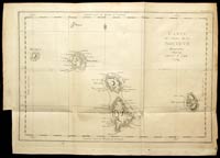 |
Carte des Isles de la Société découvertes par le Lieut.t J Cook. 1769. 13½" x 18" map from a French atlas (Tome III Pl. 1re.), showing islands discovered by Lieut. (later Capt.) James Cook on his first voyage to the South Pacific. The islands are Bola Bola (Bora Bora), Otaha, Ulietea, Huaheine, Maurua, and Tubai. Printed on laid paper. Very good; light toning and soiling. The Royal Society in London placed Cook in charge of an expedition to Otaheite (Tahiti) whose purpose was to observe the transit of Venus across the sun in June 1769. After leaving Otaheite in July 1769, Cook visited the islands on this map and raised the Union Jack there. This was the first of Cook's three trips to the South Pacific; he was killed during his third voyage by natives of Hawaii (1779).
Estimated Value $400 - 600.
View details and enlarged photo
| Unsold |
Lot 556 |
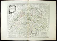 |
(Europe) A Large Late 18th Century Map of Switzerland. "La Suisse divisee En Ses Treize Cantons Et Ses Allies…Par Mr Bonne, A Venise Par P. Santini 1778." Measures 17 3/4" high x 22" wide with very large margins. An apparently combined effort by Rigobert Bonne of Paris & P. Santini of Venice. Hand colored in outline with an upper left cartouche of flowers and wheat bundles. Tables at upper right and lower left describe the thirteen Catholic and Protestant cantons of Switzerland and her allies at the time. Quite excellent condition on bright heavy paper and scarce in this fine state.
Estimated Value $550 - 750.
View details and enlarged photo
| Realized
$978 |
Lot 557 |
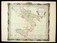 |
(Europe) An 18th Century Map of Southern Italy & Sicily. "Etats Du Roi Des Deux Sicilies…Par le Sr. Brion…Paris chez le Sr. Desnos…1766." Dimensions 10 1/2" high x 11 3/4" wide, with complete original hand color in outline and light wash. Shows the Kingdom of the Two Sicilies by Louis Brion de la Tour, Parisian cartographer of the late 18th century. A few foxing spots and paper aging at the edges, otherwise very good condition.
Estimated Value $250 - 300.
View details and enlarged photo
| Unsold |
Lot 558 |
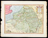 |
(Europe) An Early 1600s Map of Ancient Roman Germany, France & Netherlands. "Germaniae Cisrhenanae ut circa Julii Caesaris fuit aeta tem descriptio Auctore Phil. Cluverio." 10 1/2" high x 13 1/2" wide. A lovely ca. 1620 map in full color of northwestern Europe, from roughly east of the English Channel, in the Ancient Roman period of Julius Caesar, by Philip Cluver (aka Philippe Cluverio) of Leyden. The charming cartouche features a fierce winged and feathered creature. Slight chipping of the right and left edges and a light horizontal fold, otherwise very good condition with the old color still bright and attractive. Scarce and interesting.
Estimated Value $300 - 400.
View details and enlarged photo
| Unsold |
Lot 559 |
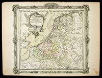 |
(Europe) Charming 18th Century Map of Holland. "Les Pays Bas Francois, Autrichiens, et Hollandais Divises en Provinces…a Paris…Desnos…1766." Measures 11" high x 12" wide with original hand color in outline and light wash; by Louis Charles Desnos. The British coast is at left of the various provinces of the Netherlands with France to the south and Germany at the west. Light paper aging, otherwise very good condition.
Estimated Value $250 - 300.
View details and enlarged photo
| Unsold |
Lot 560 |
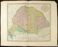 |
(Europe) Napoleonic Era Map of Hungary, Transylvania, Croatia, Serbia, Bosnia, etc. "A New Map of Hungary With Its Divisions…Principality of Transylvania, Croatia…By John Cary, 1799." 18" high x 20" wide with ample margins and full original color of delineated areas. Includes Vienna in the NW, Buda and Pest as seperate cities and Belgrade as a part of Turkey. About an inch or less has been snipped from the upper right and left corners, but far from the margins or plate impression, otherwise excellent condition.
Estimated Value $250 - 350.
View details and enlarged photo
| Unsold |
Lot 561 |
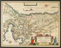 |
(Middle East) "Terre Sancta quae in sacris Terra Promissionis olim Palestina Amstelodami officina Guiljelmi Blaeuw 1629". Printed area 15" high x 19 1/2" wide in full original color and with double page Dutch text on verso. The seas with a pair of compass roses, an ancient ship and three fierce creatures. Considerable detail is seen in the interior, cities, towns, mountain ranges and the two famous bodies of water, the Sea of Galilee and the Dead Sea. An eye-catching fully colored cartouche at lower right includes Moses holding the tablet with the Ten Commandments and a second ornately dressed figure at right. This lovely map, printed in Amsterdam by William Janszoon Blaeu (1571-1638), the founder of one of the great mapmaking family firms, is in very good condition and has been handsomely matted and ready for framing. Rare.
Estimated Value $2,000 - 2,500.
View details and enlarged photo
| Unsold |
Lot 562 |
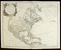 |
(N & S America) "Amerique Septentrionale…Par Le Sr. Robert DeVaugondy, fils de Mr. Robert…1750." Printed area 19" high x 23 1/4" wide with original outline color. In this finely drawn copperplate engraving, by Didier Robert DeVaugondy (1723-86), we see California as a huge peninsula along the Mexican coast. In the east, southernmost Florida seems to be dissolving into the Caribbean and farther north the Great Lakes, aptly named in this rendering, are giant inland seas.
In the American and Canadian interiors the Indian lands are named…Algonquins, Iroquois, Cheraquis, Osages, Sioux (eastern and western tribes), Apaches and many others. The Caribbean is fairly accurate but Mexico, rising far north almost to the 40th parallel, is somewhat thin in the south. Central America and the northern part of South America is also shown as are the Azores in the Atlantic. The black and white tropical motif cartouche portrays four adult natives and a child flanking an alligator in a stream.
This lovely and fascinating map is a premium copy in a superb state of preservation with full bodied bright paper and only slight age toning. Rare so nice!
Estimated Value $1,500 - 1,800.
View details and enlarged photo
| Realized
$1,725 |
Lot 563 |
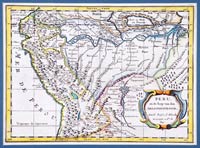 |
(N & S America) Full Color Sanson Map of Northwestern South America. "Peru en de loop van den Amazoonstroom Door N. Sanson d'Abbeville Geographe ordre. du Roy." Ca. 1660-80, by Nicolas Sanson, 8" high x 11" wide in very attractive full color. The Amazon River tributaries are featured along with Lake Titicaca and all the important Spanish Colonial cities are mentioned, i.e., Quito, Lima, Cuzco, La Paz, etc. In superb condition, expertly engraved, enhanced by the lovely color and scarce this nice. Tastefully matted and ready for framing or display. See Sanson's New Granada from the same atlas, also herein offered.
Estimated Value $400 - 500.
View details and enlarged photo
| Realized
$426 |
Lot 564 |
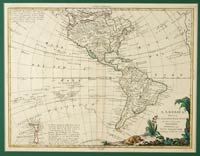 |
(N & S America) Handsome Map of the Americas Drawn in the Year of Our Independence, with a Captain Cook Update. "L'America divisa…Principali Stati…Venezia 1776…Antonio Zatta." Measures 12" high x 16" wide with original outline color. In this 1776 representation of the western hemisphere, the body of North America is considerably distorted, especially the western boundary bulging far into the Pacific. Mexico emerges from the central portion with California shown as a long craggy finger and the Floridian peninsula a hooked appendage. In the lower left, considerable attention is given to Captain Cook's recent discoveries, especially in New Zealand, and a tracing of his circuitous wanderings throughout the Pacific is recorded. At lower right a fully colored cartouche features a sleeping lion, correctly predicting the potential of the New World. This premium copy on bright paper is in excellent condition, tastefully matted and ready for framing. Very scarce this nice.
Estimated Value $1,000 - 1,250.
View details and enlarged photo
| Realized
$1,150 |
Lot 565 |
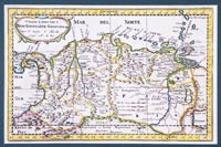 |
(N & S America) Mid 17th Century Full Color Sanson Map of Colombia and Panama. "T' Vaste Landt Van't Niew Koningryk Granada door N. Sanson d'Abbeville Georgr. ordre du Roy." Ca. 1660-80 by Nicolas Sanson; 7 1/2" high x 11 1/2" wide in lovely full color. New Granada, a most important part of Spain's colonial empire, is superbly engraved in fine detail including all the major rivers and cities along with the island chains off the northern coast. In superb condition with firm bright paper and scarce in this choice state of preservation. Handsomely matted ready for framing or display and a perfect mate to the Sanson "Peru" also presently offered.
Estimated Value $400 - 500.
View details and enlarged photo
| Realized
$426 |
Lot 566 |
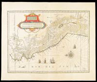 |
(N & S America) "Peru Amstelodami, Guiljelmus Blaeu excudit." Ca. 1640s, printed area 14 3/4" high x 19 1/4" wide, with orginal hand outline color and perhaps a light wash; the cartouche, with a scale of miles, in full original color. This lovely view by William Blaeu was printed in Amsterdam. It shows the Audiencia of Peru, established in 1542 (the Viceroyalty of Peru consisted of most of South America at this time and was sub-divided into several audiencias for administrative purposes), with north pointing to the viewer's left as indicated by the compass rose at lower right.
A quartet of Spanish galleons ply the coastal waters amid several spouting whales equal in size to the ships. Inland we note the high mountain Lake Titicaca and toward the coast Lima and its seaport Callao. At this period, gold and silver mined nearer the Pacific coast made its way to Lima for shipment to Panama, then across the isthmus to Havana en route to eventual trans-shipment to Spain in the annual treasure fleets, many of which never successfully made the crossing.
The sheet margins have been very slightly trimmed, though still ample and the paper has toned from age, otherwise this is an excellent copy with two full pages of Latin text on verso. Rare and important to the history of Spanish Colonial America.
Estimated Value $1,200 - 1,500.
View details and enlarged photo
| Unsold |
Lot 567 |
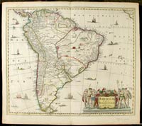 |
(N & S America) Superb Early 17th Century Continental Map of South America. "America Pars Meridionalis", by Jan Jansson, Amsterdam, ca. 1640. Printed area 18" high x 21 1/2" wide plus margins, in original outline color with a fully colored cartouche. From the north, including parts of Central America and the Isthmus of Panama to the Straits of Magellan and Cape Horn in the south. Interior details show a hunting scene, dwellings, village life, wild animals and in both oceans, sailing ships, native boats and sea monsters. The mouth of the Rio de la Plata is huge with myriad large islands upstream and a very sizeable lake is seen to the northeast. The large cartouche portrays six adult natives and one child along with flora and fauna. Only slight aging of the paper at the edges, otherwise this rare and important map is in excellent condition.
Estimated Value $1,000 - 1,250.
View details and enlarged photo
| Unsold |
Lot 568 |
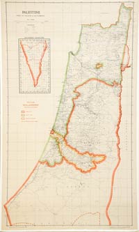 |
Palestine, Index to Villages & Settlements, 1947. "Detailed Map / Royal Commission / Partition Boundaries," 39x23". Fine. Printed at lower right: "Compiled Drawn & printed by Survey of Palestine, April 1946," and just under that: "Overprinted by Survey of Palestine May 1947." The Arab State is outlined in red; the Jewish State in green; and mandated enclaves by yellow inside a red border. An inset of Southern Palestine is at upper left. The British Royal Commission, headed by Earl Peel, recommended that the British Mandate of Palestine eventually be abolished, except for a corridor stretching from Jerusalem to the Mediterranean Coast just south of Jaffa, and that the land under the Mandate be apportioned between Arab and Jewish states. The Jewish state would receive a smaller territorial area in the mid-west and north, from Mount Carmel to south of Be'er Tuvia, as well as the Jezreel Valley and the Galilee. The Arab state would receive territory in the south and mid-east, including Judea, Samaria and the Negev desert.
Estimated Value $500 - 750.
View details and enlarged photo
| Unsold |
|
|