
|
Sale 35
Manuscript and Collectibles Auction
| Lot |
Photo |
Description |
Realized |
Lot 464 |
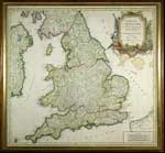 |
1753 Handcolored Map of England. "Le Royaume d'Angleterre divisé selon les sept Royaumnes, ou Heptarchie des Saxons, avec La Principauté de Galles…." published in France by Robert, 18¾" x 20". Showing shires and counties, as well as the towns and cities; also part of Scotland and the eastern edge of Ireland. Matted and framed to 20¾" x 22". Ready for display.
Estimated Value $300 - 400.
View details and enlarged photo
| Realized
$391 |
Lot 465 |
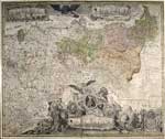 |
Map of the Kingdom of Prussia, c. 1750s. "General Carte der gesamten Kõniglichen Preussischen Läder," by F. D. Schleuen, 23" x 27½". Hand-tinted with wonderful engravings. Showing all of Prussia, and part of Holland and Poland. Overall edge soiling; edge tears of 3½" at right and bottom and 2½" at left, as well as some separation at folds across the bottom and a light stain in lower right corner. Still very attractive and quite decorative. Archivally shrink-wrapped and ready for framing.
Estimated Value $250 - 300.
View details and enlarged photo
| Realized
$228 |
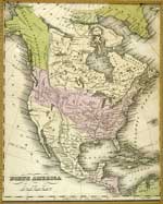
Lot 466 |
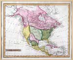 |
1814 Hand-colored Map of North America. Engraved by J. Russell and published by Nuttel, Fisher, & Dixon, Liverpool, July 1814. 7¼x8¾"; matted and framed to an overall size of 12x13½". Showing North and Central America. Very fine.
Estimated Value $150 - 200.
View details and enlarged photo
| Realized
$253 |
Lot 467 |
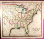 |
1823 Map of the United States of America. Hand-tinted, engraved by J. Warr, Jr., No. 110 Walnut Street, Philadelphia. This 17x19" map was the major frontispiece to the 1823 edition Business Atlas of the United States. Fine and clean with strong vibrant colors; faint file folds.
Estimated Value $400 - 600.
View details and enlarged photo
| Realized
$575 |
Lot 468 |
 |
North America, c. 1830s. 9½x7½" highly-delineated map showing the United States, the British Empire to the north, Russian Possessions, Greenland, Mexico (including Texas) and Central America. Burlap-textured matt in a 14x12" walnut frame.
Estimated Value $125 - 150.
View details and enlarged photo
| Realized
$144 |
Lot 469 |
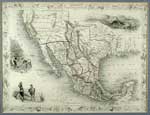 |
Mexico, California and Texas, c. 1850. 10x13", matted and framed to an overall size of 14¾x17¾" "New or Upper California" encompasses several present-day states, and "The newly discovered Gold districts" are marked in yellow The Mexican are delineated in color, as is Texas, as it appeared then. Vignettes of gold miners, Mexican peasants, and ruins at Yucatan decorate the map.
Estimated Value $200 - 300.
View details and enlarged photo
| Realized
$357 |
Lot 470 |
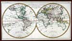 |
18th Century Double Hemispheric World Map. "L'Ancien Monde Et Le Nouveau" by R. Bonne, Paris, ca. 1780. A most attractive map of the world with printed area aprox. 16" x 9", and hand colored in outline. In this version, Greenland is still attached to North America and Tasmania, as "Terre De Diemen", is likewise seen as an apendage to Australia. Alaska is shown as a group of scattered islands. Superb condition and handsomely matted, ready for framing.
Estimated Value $275 - 350.
View details and enlarged photo
| Realized
$546 |
Lot 471 |
 |
A General Map of North America From the Best Authorities. Hand-colored Map of North America, c. 1770s, 7½x9", matted and framed to 12x14". Showing the entire North American continent, with the American colonies marked. Many Indian tribes are named.
Estimated Value $150 - 200.
View details and enlarged photo
| Realized
$437 |
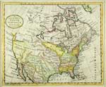
Lot 472 |
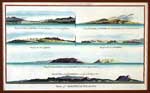 |
Hawaiian Islands in the 18th Century. "Views of Sandwich Islands", by Alexander Hogg, published London ca. 1790. A beautifully hand colored copper plate engraving showing six landscape views of the Hawaiian Islands. Printed area aprox. 14" x 9". Views include: "Mowee", "Owhyee", two different of "Atooi", "Woahoo" and "Oneehow", all bold impressions. Excellent condition and attractively matted ready for framing.
Estimated Value $200 - 250.
View details and enlarged photo
| Realized
$546 |
Lot 473 |
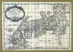 |
Lovely 18th century Japanese Map. "Carte de l'Empire du Japon Pour servir a l'Histoire Generale des Voyages", Paris, 1752 by Jacques Nicolas Bellin(1703-72), as issued from the Histoire Generale des Voyages. Printed area 12 1/2" x 8 1/2". A boldly impressed black on white engraving as originally issued, with baroque cartouche at upper left. This scarce view of the Japanese islands is still quite speculative and distorted indicative of the lack of accurate coastal surveys available to Parisian publishers of the period. Excellent condition and nicely matted for display.
Estimated Value $500 - 600.
View details and enlarged photo
| Unsold |
Lot 474 |
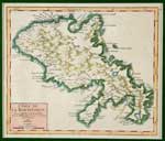 |
Lovely 18th Century Map of Martinique. "L'Isle De La Martinique…1749" by Robert De Vaugondy. Printed area 7 1/2" x 6 1/2". A beautifully rendered copperplate engraving with old hand coloring. Excellent condition, handsomely matted and ready for framing or display as is.
Estimated Value $200 - 250.
View details and enlarged photo
| Unsold |
Lot 475 |
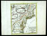 |
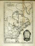
New England & Mid Atlantic Regions. "Nouvelle Angleterre Nlle. York, Nlle. Jersey, Pensilvanie Mariland et Virginie." A handsome and important map from the Atlas Portatif, Universel et Militaire. By Gilles Robert de Vaugondy, 1749, Paris. A copperplate engraving with original hand outline color. Printed area is 7 1/2" x 6 3/8". Pedley-468. After the 1748 Treaty of Aix-la-Chapelle, which ended the War of the Austrian Succession, Robert de Vaugondy issued an updated edition of his atlas with more detailed maps of the areas changed by the war and treaty agreements. In this map, we see the political boundaries in North America as France saw them at the culmination of the American phase of the conflict, also known as King George's War. Excellent condition.
Estimated Value $450 - 500.
View details and enlarged photo
| Realized
$575 |
Lot 476 |
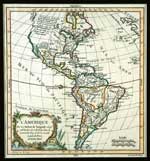 |
North & South America. "L' Amerique" by Robert de Vaugondy, Paris, 1772. Printed area 9 3/4" x 8 3/4", with original outline color. A charming and attractive map of the western hemisphere with a colored cartouche at lower left. California, previously thought to be an island, is now shown as a huge wide peninsula attached at the northern extremities. In excellent condition, nicely matted and ready for framing.
Estimated Value $425 - 475.
View details and enlarged photo
| Realized
$431 |
Lot 477 |
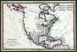 |
North America. "Amerique Septentrionale" by R. Bonne (1727-95), Paris ca.1780, printed area 12 1/2" x 8 3/4", with original hand outline color. Among the most popular maps from the "Atlas de toutes les parties connues du globe terrestre…" by G. T. F. Raynal, this handsome map of North America shows the coastal areas well populated. The interior regions west of the Great Lakes are largely unexplored, with the west coast showing anchorages from Alaska to Baja with California, coastal and peninsular, misshapen though attached to the mainland. The Caribbean and West Indies are well delineated along with Central America & the northern part of South America, and Greenland is still shown as part of the North American continent. Excellent condition, handsomely matted and ready for framing.
Estimated Value $275 - 350.
View details and enlarged photo
| Realized
$518 |
Lot 478 |
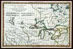 |
North Central USA, Canada & the Great Lakes. "Partie Occidentale du Canada, Contenant les cinq Grands Lacs, avec les Pays Circonvoisins," ca. 1780 by Rigobert Bonne (1727-1795), printed in Paris. Copper plate engraving with original hand outline color, printed area 12 1/2" by 8 1/2". Portrays the Great Lakes area and the lands north, south and west, mentioning the tribes predominant therein, i.e. Sioux, Outagami, Illinois and Iroquois, and Fort du Detroit. In excellent condition, nicely matted and ready for framing.
Estimated Value $275 - 325.
View details and enlarged photo
| Realized
$345 |
Lot 479 |
 |
Partie du Nord de l'Amérique…. By M. Bonne, c. 1730s, 11¼x8¼", matted and framed to 14x10". Showing the American colonies, Louisiana, and French Canada, up to Greenland. Light toning, creasing and folds. Decorative title cartouche.
Estimated Value $150 - 200.
View details and enlarged photo
| Realized
$230 |
Lot 480 |
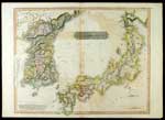 |
Rare Early 19th Century Map of Korea and Japan. "Corea and Japan" by Hall for Thomson's New General Atlas, Edinburgh, ca. 1817. Handsomely engraved and with original hand color, showing the islands of Japan and Korea correctly as a peninsula. At lower left is a lengthy excerpt from Captain Hall who in describing the many islands off the Korean coast mentions that "every attempt to enumerate them…after a time became quite hopeless", from "Capt. Hall's Account of a Voyage of Discovery to the West Coast of Korea in H.M. Ship Aleeste and Sloop Lyra 1816." There is some offsetting of the image from being folded vertically in the original atlas, otherwise very nice condition for this rare map.
Estimated Value $550 - 750.
View details and enlarged photo
| Realized
$518 |
Lot 481 |
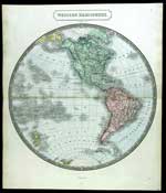 |
Western Hemisphere. An attractive circular map of the Americas, the geographic image 16 1/2" in diameter, by Sidney Hall and published in London ca. 1830. With attractive light hand coloring throughout except at the poles. The Pacific islands particularly well represented. Excellent condition.
Estimated Value $125 - 175.
View details and enlarged photo
| Realized
$144 |
|
|