|
Sale 18
| Lot |
Photo |
Description |
Realized |
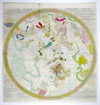
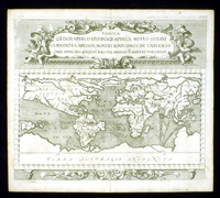
Lot 2181 |
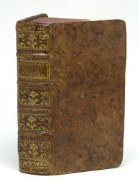 |
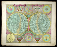
[Book] Le Geographe Manuel. Paris. 1771. Miniature atlas with six fold-out maps. One double hemisphere world map and four continental maps. A beautiful piece.
Waterdamage inside front cover affects inner edge of front cover, endpapers and title page (not severe); pencil ID on reverse of marbled endpaper; pasted to inside endpaper: "R. J. F. Leclerc; Chevalier de l'Ordre Royal de la Legion d'honneur…"; penned in:" inspecteur des eauf delusceries couvies poud. de la societe des sciences DuGusrbin… No. de l'Inscript "637"(manu) No. de Vol. 1.
Estimated Value $500 - 600.
View details and enlarged photo
| Unsold |
Lot 2182 |
 |
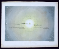
de Fer: Le System Ptolomee, Copernic, Descartes, Tycho Brahe. C. 1700. Paris. 13 x 9". Clear, sharp chart engraved by H. Van Loon is a beautiful example of de Fer's work. Uncolored map has minor surface soil, is otherwise fine.
Estimated Value $350 - 400.
View details and enlarged photo
| Realized
$230 |
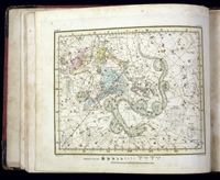
Lot 2183 |
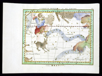 |
Fortin: L'Eriden, Orion et Le Lievre. 1776. Paris, published as part of Jean Fortin's Atlas Celeste de Flamsteed. 12¼ x 9". Image: 10 x 8". Flamsteed, first Astronomer Royal at the London Observatory, was one of the most influential figures in 18th century astronomy as he made a thorough study of the heavens and mapped constellations -- his work even influenced his British colleagues Isaac Newton and Edmund Halley. Flamsteed was in regular correspondence with international colleagues, including at the Academie Royal in Paris. Flamsteed's influence on French astronomers is clear, given that the publication of Fortin's work took place almost fifty years after Flamsteed's death.
"24" at top right. Very, very minor toning to edges. Clear, vibrant color. Fine condition.
Estimated Value $600 - 800.
View details and enlarged photo
| Unsold |
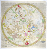
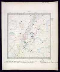
Lot 2184 |
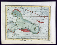 |
Fortin: La Baleine. 1776. Paris, published as part of Jean Fortin's Atlas Celeste de Flamsteed. 12¼ x 9". Image: 10 x 8".
"23" at top right. Very, very minor toning to edges. Clear, vibrant color. Fine condition.
Estimated Value $200 - 300.
View details and enlarged photo
| Unsold |
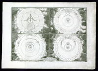
Lot 2185 |
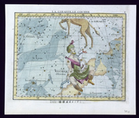 |
Fortin: La Giraffe, Le Cocher. 1776. Paris, published as part of Jean Fortin's Atlas Celeste de Flamsteed. 12¼ x 9". Image: 10 x 8".
"4" at top right. Very, very minor toning to edges. pencil ID verso; hinge residue verso. Clear, vibrant color, with gold-accented stars. Fine condition.
Estimated Value $250 - 300.
View details and enlarged photo
| Unsold |
Lot 2186 |
 |
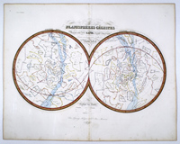
French Celestial Hemispheres. C. 1730. 10¼ x 8". Image: 9 x 7".
Colored illustration on pale green-blue hand tinted paper. Some toning to edges; edges somewhat raggedly trimmed; pencil ID verso. Very good condition.
An unusual little piece.
Estimated Value $300 - 500.
View details and enlarged photo
| Unsold |
Lot 2187 |
 |
German celestial map 1841. "Der südliche gestirnte Himmel / Entw u. gez.u. L.C. Bär / 1841" Gotha: Justus Perthes. 15 x 12".
Strong horizontal and vertical folds; toning to edges; southern sky is toned at edges and has a nick at the bottom edge; right edge trimmed unevenly; pencil ID verso. Delicate color.
"Der nördliche gestirnte Himmel / Engw. u. gez.v. A. Stieler / neu gestochen 1840 von [?] Ausfold" Gotha" Justus Perthes. Slightly smaller than one above.
Less toning; strong vertical and horizontal folds; right side somewhat unevenly trimmed; pencil ID verso. Delicate color.
Estimated Value $400 - 500.
View details and enlarged photo
| Unsold |
Lot 2188 |
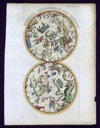 |
Hemelsse Vertooninge der Teekenen. Early 18th century. Likely from a Dutch atlas of the period, "3 Deel Pag. 146" printed at top right. 7 x 9¼". A unique chart oriented vertically rather than horizontally.
Toning to edges with minor crumpling; dampstains upper left and middle right margins; pencil ID verso. Strong color. Good to very good condition.
Estimated Value $400 - 500.
View details and enlarged photo
| Unsold |
Lot 2189 |
 |
[Book] Jamieson, Alexander A Celestial Atlas. 1822. London: G. & W. B. Whittaker & N. Hailes. 10 x 11.5". Engraved title and dedication pages; 30 copper or steel plate engraved hand colored (but two) celestial plates. Tissue guards and related text for each engraving. A beautiful tribute to Jamieson's work.
Original covers well worn; front and rear hinges loose, but covers still attached; title page shaved at top; scattered staining, toning and foxing to text pages; dampstaining to title page; tissue guards fairly heavily foxed: last page half loose but attached. Almost all of the plates are very clean and clear, with bright color. Good condition.
Estimated Value $3,000 - 4,000.
View details and enlarged photo
| Realized
$2,415 |
Lot 2190 |
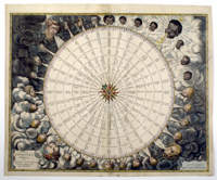 |
Table of Winds: Amstelodami Apud Ioan Ianßonium. C. 1650. Amsterdam. Jansson. 18¾ x 22½". Image: 17½ x 22". The delicate cherubs adorning this map symbolize the winds that governed sailors' lives and, most importantly, served as direction markers for the pilots of ships. Zephyr, Boreas, Notus and Eurus, the powerful Greek deities of the wind, were transformed into playful cherubs and joined by other figures as travelers charted the wider world. This lovely compass rose presents windheads as the races of the world and the four seasons.
Printing flaw resulting in vertical crease 2" to right of center fold. Old professional repairs: Center fold strengthened with some repairs/color touchups to tiny wormholes, minor adhesive show-through does not detract. Backing strip on lower right edge to repair/strengthen scattered small holes and nicks at bottom edge of image; color touchups; two paper repairs verso upper left corner, one to edge results in minor adhesive show-through; scattered surface soil and foxing recto and verso; handful of scattered nicks to margins.
Beautiful early color. Good to very good condition.
Estimated Value $3,000 - 3,000.
View details and enlarged photo
| Unsold |
Lot 2191 |
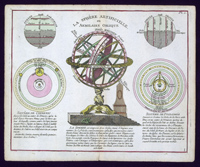 |
La Sphere Artificielle ou Armilaire Oblique. C. 1750. 9 x 7".
½" split lower centerfold; minor toning to edges. Very good to near fine condition.
Wonderful color makes this scientific illustration a little gem.
Estimated Value $300 - 400.
View details and enlarged photo
| Unsold |
Lot 2192 |
 |
LaPie's Atlas Universel: Planispheres Celestes. 1828. Paris. 24 x 18". Demonstrating the scientific bent of the nineteenth century cartographers, the elaborate allegorical figures of the constellations have been replaced with basic renderings of the star groupings.
"2" at top right. Blindstamp in white field indicates LaPie's Atlas. Minor toning at edges, pencil ID verso. Generally very good condition.
Estimated Value $400 - 500.
View details and enlarged photo
| Unsold |
Lot 2193 |
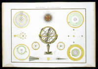 |
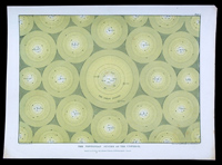
Systêmes Planétaires from LaPie's Atlas Universel. 1828. Paris. Elephant Folio.
"1" at top right; blind stamp in white field indicating LaPie's Atlas. Minor surface soil; minor toning and foxing to edges verso, one stain at bottom left corner; smaller one at bottom right; binder stub removed, some residue left verso; pencil ID verso. Lovely color. Good to very good condition.
Estimated Value $400 - 500.
View details and enlarged photo
| Unsold |
Lot 2194 |
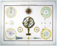 |
Systemes Planetaires LaPie. 1828. Paris. Elephant Folio.
"1" at top right; blind stamp in white field indicating LaPie's Atlas.
Blindstamp; toning to edges with minor foxing; one tape repair bottom center margin at split.
Estimated Value $400 - 500.
View details and enlarged photo
| Unsold |
Lot 2195 |
 |
Tobias Conrad Lotter celestial map (in Latin). Planispherium Coelestre. 1772. Augsburg. 23 x 19". From Atlas Novus.
Dampstaining along bottom edge below map image, at upper right corner; surface soil throughout (likely) contemporary ink ID verso; pencil ID verso; binders stub has minor tears, is still intact. trimmed almost to plate mark. Original color has faded somewhat, but an interesting side effect is that the paint used to accentuate the galaxy has left an apparent metallic residue that flouresces brightly under UV. Overall, very good condition.
A gorgeous double hemisphere map in the Hevelius style, as formatted by Eimmart.
Estimated Value $2,500 - 3,000.
View details and enlarged photo
| Unsold |
Lot 2196 |
 |
Lotter: Planispherium Coeleste. C. 1772. Augsburg. 23 x 19". From Atlas Novus.
Minor dampstain, otherwise very good condition.
Estimated Value $2,000 - 2,500.
View details and enlarged photo
| Unsold |
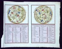
Lot 2197 |
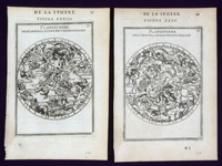 |
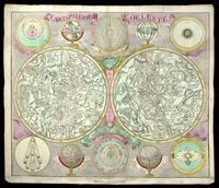
Pair of small French Celestial Maps with text. Published 1683. Paris. 4 x 5". From Description de l'Universe.
Tiny nicks where the two pages were removed from book; minor toning to edges; pencil ID at bottom margins both pages, recto and verso. Generally very good condition.
Detailed small maps showing Planisphere Des Constellations Septenrionalles and Planisphere Des Constellations Meridonalles with text and lists of constellations verso.
Estimated Value $600 - 800.
View details and enlarged photo
| Unsold |
Lot 2198 |
 |
Four diagrams regarding celestial charting French. C. 1790. Paris. 10 x 11½". "Des Planetes en Particulier"shows the six known planets and their oribits. "Observations" features the earth in four positions. "La Maniere de Reconnoitre les Principales E'toiles dans le Ciel" shows a the night sky and a beautifully rendered Milky Way. "Des Planetes. Gnomon de l'Eglife de St. Sulpice de Paris" shows use of a gnomon to determine solstices. Four absolutely lovely works on thick hand land paper.
Four hand-tinted and colored pale blue-green pages in French. Beautiful illustrations with detailed text to either side.
Binder's stub removed on all four; they all shoe some degree of toning to the edges. pencil ID verso and at bottom right. Generally very good to near fine condition.
Estimated Value $800 - 1,000.
View details and enlarged photos
| Unsold |
Lot 2199 |
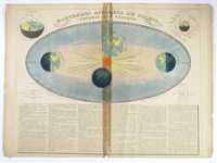 |
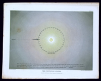
Movement of the Sun, French c. 1836. C. 1840. Paris. "Compose et dessine par H. Nicollet / LeText et les fig. Suppl. Par E. Soulier Atlas Universel no. 1 at UR pub. Andriveau Goujon."
Adhesive residue verso browned with show through along center fold; center fold split to and bottom with tiny areas of paper loss at both ends; small nicks scattered at edges; paper is toned; pencil ID verso.
Brilliant orange sun anchors beautifully colored rendering of the movement of the sun and the seasons.
Estimated Value $400 - 500.
View details and enlarged photo
| Unsold |
Lot 2200 |
 |
Muggletonian Celestial Print, "The Newtonian System of the Universe". 1846. London. Engraved by W.P. Chubb & Son. Colored by George Baxter, using his oil color printing technique. 12 x 10".
Please see the lot below for information on the Muggletonians.
Estimated Value $350 - 450.
View details and enlarged photo
| Unsold |
Lot 2201 |
 |
Muggletonian Celestial Prints, Set of Four. 1846. London. Engraved by W.P. Clubb & Son. Colored by George Baxter, using his oil color printing technique. 12 x 10". Beautifully colored renditions of the Solar System drawn by Isaac Frost, the leading developer of the Muggletonian view of astronomy. The Muggletonians were a small religious group which existed in England from the late 17th to the early 20th century and frowned on modern science and heliocentric astronomy. Frost depicts the Newtonian system (plates 1 and 3) and "The System According to Holy Scriptures" (plates 7 & 9) in lovely detail. These prints were likely circulated to sect members only.
Frost's lovely drawings are enhanced by George Baxter's innovative oil color process, a system which creates beautiful tones, but proved to be too costly for commercial use. In addition to being rare celestial prints, these are among the rarest of Baxter's prints. Minor toning to edges, else near fine.
Estimated Value $2,000 - 3,000.
View details and enlarged photo
| Unsold |
Lot 2202 |
 |
Muggletonian Prints III. 1846. London. Engraved by W.P. Clubb & Son. Colored by George Baxter, using his oil color printing technique. 12 x 10". Set of four diagrams, three Newtonian and one Holy Scripture.
Dampstaining and toning to edges; some foxing in images; pencil ID verso. Generally good condition.
Estimated Value $400 - 500.
View details and enlarged photo
| Unsold |
Lot 2203 |
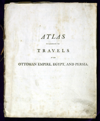 |
[Book] Olivier, G.A. Atlas to Illustrate the Travels in the Ottoman Empire, Egypt and Persia. Undertaken by Order of the Government of France, During the First Six Years of the Republic; London, T.N. Longman and O. Rees, 1801. 12½ x 10". Sixteen plates, includes maps and depictions of native costume, flora and fauna (including incredibly rendered seashells). Three pages of text explain the plates in detail (in particular noting that Plate IX required "particular care in the execution", was not finished at the time of printing and would be delivered with plates from Travels in Egypt).
No covers. Pencil doodles on the back pages and inside on a few blank pages; Plate I, a map of Greece, has a 4" tear at the left edge; scattered moderate to severe surface soil, foxing and dampstaining throughout. The maps are clear with nice detail.
Olivier, an inveterate traveler, was a member of the National Institute, of the Society of Agriculture, of the Department of the Seine, and many other notable bodies of the time.
Estimated Value $1,500 - 2,000.
View details and enlarged photo
| Unsold |
Lot 2204 |
 |
Hemisphaeium Australe English 1690. Drawn by Joseph Harris. C. 1721. London. 25 x 25". Legend: "stellarum Fixarum Hemisphaerium Australe / The Southrn Hemisphere Projected on the Plane of the Aequator in which all the Stars in the Britannick Catalogue and those Observ'd by Dr. Edm. Halley at the Isl. of st. Helena are carefully layd down for the Year 1690 by Joseph Harris (6)."
Printed at bottom: "Engraved and Sold by I Senex at the Globe, over against ST. Dunstans Church in Fleetstreet. Where may be had the Zodiac, containing all the Stars hitherto Observed, to which the Moon or Planets can at any time Apply: very usefull in Astronomical Observations, particularly in finding the Longitude at Sea. Also the Solar System describing the Paths of the Planets and Comes from Sr. I. Newton, by Wil. Whiston, MA."
John Senex was a successful cartographer and publisher in England and was elected to the Royal Society in 1728. Senex published these charts in response to the great demand in England for single-sheet, reliable star catalogs; they were popular with both astronomers and navigators as England began her imperial and commercial spread across the globe.
Trimmed almost to text; skillfull professional old repairs -- at top center edge and 10" tear from left edge into Cetus and Phoenix; incidental surface soil. Good to very good condition.
Estimated Value $1,200 - 1,500.
View details and enlarged photo
| Unsold |
Lot 2205 |
 |
Hemisphaerium Boreale 1690 English. C. 1721. London. 25 x 25". "Stellarum Fixarum Hemisphaerium Boreale / The Northern Hemisphere projected on the Plane of the Aequator in which all the Stars contain'd in the Britannick Catalgue (as publish'd by D. Halley) and carefully laid down and adapted to the beginning of the Year 1690, the Asterismes being drawn to answer the description of the Ancients. (3)"
Trimmed almost to text; skillfull professional old repairs -- one at top center, two 10 1/2" tears from right; late color; incidental surface soil. Good to very good condition.
Estimated Value $1,000 - 1,200.
View details and enlarged photo
| Unsold |
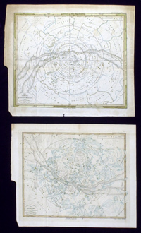
Lot 2206 |
 |
Society for the Diffusion of Useful Knowledge: Maps of the Stars. 1830. London. 16½ x 13½". Set of six celestial maps with one introductory sheet, likely issued in a large portfolio (not present). Better known for their detailed city and country maps, the Society for the Diffusion of Useful Knowledge (SDUK) was dedicated to the education of the common man. This set of charts was indeed useful, as the period notes indicate. An exceptional lot -- complete sets of these celestial maps seldom come to market.
Scattered pencil ID verso; all six maps have commentary penned in the upper and lower margins. Beautiful, soft, original color. Very good condition.
Estimated Value $1,000 - 1,500.
View details and enlarged photo
| Unsold |
Lot 2207 |
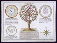 |
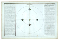
Sphere Armillaire. C. 1780. Anonymous. Likely Paris. 10 x 8". A beautiful armillary sphere dominates this work, which also depicts the astronomical theories of Ptolomy, Copernicus and Tycho Brahe. The lower right corner is decorated with a "Rose du Boussole".
Intricate copperplate engraving with modern color. Binder's stub removed. Toning to edges is very light. Near fine condition.
Estimated Value $300 - 400.
View details and enlarged photo
| Unsold |
Lot 2208 |
 |
Zahn, Johann: Five Engravings from Mundus Mirabili…Speculæ Physico-Mathematico-Historicæ. 1696. Nuremberg. 14 x 16".
These engravings are "Tabula Geographico-Hydrographica Mous Oceani Currentes…", a world map; "Opus Naturæ / Opus Intelligentiæ…" a cross-section of the earth; "Schema Corporis Solaris…" and "Publica Naturæ…", both celestial maps; the final chart is titled "Prognosticon Temporis ex Contressuet Configurafione Planetarium." There is minor toning and soiling to edges; general overall (very mild) soil; pencil IDs to bottom margins; some inconsequential splitting at margins. Generally very good condition.
This set of five charts is a superior offering, a scarce grouping taken from a German scientific work by monk/scientist Johann Zahn. The world map itself is rated scarce by R. Shirley, the set together is incredibly difficult to find. The engravings are very decorative and ornate, in spite of being uncolored, with scrollwork, frolicking cherubs and beautifully rendered windheads.
The "Tabula Geographico-Hydrographica…" depicts the continents as known, with " Terra Australis Incognita" at the bottom and the northwest passage depicted at the top. With elaborate depictions of ocean currents, volcanos and other physical, terrestrial and oceanic features.
"Opus Naturæ…", a creative depiction of earth's cross-section, shows volcanic activity above and below the surface. Six windheads blow playfully among the clouds.
"Schema Corporis Solaris" carries an attribution to Kircher (1635) and shows a stylized and highly decorative illustration of the sun's surface. Eagles, cherubs and flowers embellish the engraving.
"Stellarumque Choros et Mundi…" shows the orbits of the moon and stars. Large floral garlands decorate the fields around the sphere.
"Prognosticon Temporois…" lists constellation names and signs of the Zodiac -- a great example of the 17th century's blend of science and ancient folklore.
Estimated Value $9,000 - 10,000.
View details and enlarged photo
| Unsold |
Lot 2209 |
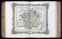 |
[Book] Zannoni, R. Atlas Historique De La France Ancienne Et Moderne. Paris, 1765. 11½ x 8½". 16 pages of text; 59 colored maps, two fold out to near-folio size. From M. Rizzi Annoni de l'Academie r.le des Sciences et Belles Lettres de Gottingue. Mis au jour et execute par le s. Desnos Ingl. Geogr. pour les Globes, spheres et Instrumens de mathematic. Beautiful engraved title and dedication pages.
Leather and paper-covered boards show rubbing and much wear; front cover binding somewhat loose but in no danger; last map (fold-out) is very loose -- coming out of binding strip, has repair to correct splitting at center horizontal fold; some pencil doodling to inner covers; pencil ID; stain inside map 16, a few other marks to page edges; minor scattered toning to page edges. The maps, which illustrate France's history from the time of the Gauls to 1765, are beautifully colored and generally very clean and sharp.
Estimated Value $2,500 - 3,000.
View details and enlarged photo
| Realized
$1,725 |
Lot 2210 |
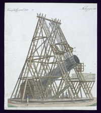 |
1798 Text and Illustrations. Three illustrations, each with a descriptive page of text (one side German, one side French) 7¾ x 9". Original color. pencil ID verso indicates "1798". Minor toning to edges only.
Saturn and its rings. "Vermischte Gegenstände XV / B. III No. 15"
The Moon and its Mountains "Vermischte Gegenst. VI. Biii. No. 1"
Herschel's telescope "Vermischte Gegenst. XII B. Iii No. 6": two small spots in text.
William Herschel's telescope was the largest of its day, enabling the astronmer to view Saturn and discover Uranus. Hershcel's reflecting telescope pictured here was one of the marvels of the age.
Near Fine.
Estimated Value $300 - 400.
View details and enlarged photo
| Unsold |
Lot 2211 |
|
Kitchin: Set of Seven Maps. Seven small folding maps (quarto to oblong quarto) engraved based on the work of noted cartographer Thomas Kitchen. All mid-18th century. The maps are: "Europe Drawn from the best Authorities"(likely published 1773); "Ireland Drawn from the latest Authorities"; "East Indies from the best Authorities"; "South America Drawn from the best Authorities"; "Poland Lithuania and Prussia Drawn from the latest Authorities"; "England and Wales Drawn from the best Authorities"; "Spain and Portugal drawn from the latest Authorities". The maps are likely from a few different publishers of Kitchener's works, as the cartouches and typefaces differ slightly among them. These are lovely maps sized for ease of transport from the era of Britain's expansion.
The maps all show some tape residue verso; toning to edges; minor surface soil; a few with tiny splitting at folds. Generally good to very good condtion.
Estimated Value $300 - 400.
View details
| Unsold |
Lot 2212 |
|
Moll and Others: Assorted Maps. Lot of eight quarto or oblong quarto maps.
Four maps by cartographer Herman Moll, dating to 1732 and 1727. Denmark is represented twice, once from each date; Sweden and Norway appear together on a map from 1732; and Northwest Germany is dated 1732. All of the maps have an old ink notation in the cartouche of the date of publication. Delicate color. Toning, some tape residue verso, other small flaws. Generally good to very good condition.
An uncolored map of Sweden and Norway from American cartographer S. Walker of Boston is in very good condition. The map was engraved by R. Campbell of Phildelphia in 1832.
A November 1, 1819, mail map of England is in very good condition. The delicate colors accent the map which highlights the great commercial centers of England. A nice piece relating to the beginnings of the incredible growth England experienced in the mid eighteenth century.
"Turky in Europe and Hungary" is presented in a style reminiscent of Kitchin's but carries no attribution or printer. Minor toning, as with all the others, mounting tape residue verso, but generally very good condition.
"Pannonien Mösien, Dacien und Illyricum" is a German map, presumably from an atlas or text book, as it carries the notation "Welthist. Theil XII" in the upper right corner. This detailed map shows the mountain ranges and other natural features of this wild land. Minor foxing and toning throughout. Good condition.
Estimated Value $400 - 500.
View details
| Unsold |
Lot 2213 |
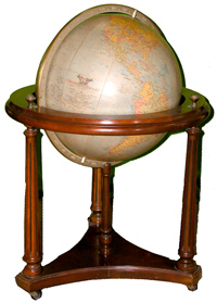 |
Large School or Library Size Globe. United States, c. late 1950's-1960's. Manufactured by Replogle Globes, of Chicago. The 16" globe covered in plasticized paper, showing in color the political boundaries of the world's nations at the time, along with ocean currents, shipping routes, plus other water related details, along with the usual longitude and latitude markings. Globe set in circular metal frame, allowing it to spin, and which is removable from the globe's nicely finished, Federal-style carved and turned wooden base. In very fine plus, or better, condition, the globe remains an educational and decorative object of display. Overall height: 31-1/2".
Estimated Value $300 - 400.
View details and enlarged photo
| Realized
$173 |
Lot 2214 |
|
Withdrawn
| Unsold |
Lot 2215 |
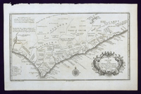 |
Africa. Two maps and five prints of early 18th century Africa, from an unidentified volume: (1) "A Map of the Gold Coast, from Issini, to Alampi, by M. D. D'Anville, April 1729," engraved by G. Child, uncolored, 8" x 13-3/4", with an attractive title cartouche and a wind rose. (2) "A Chart of the Western Coast of Africa, from the Straits of Gibraltar to eleven Degrees of North Latitude; including the Canary & Cape Verd Islands Drawn from the French Chart of the Western Ocean Published in 1738 by order of the Count de Maurepas…." by Thomas Kitchin, 10-1/4" x 8". (3) Print showing "North Prospect of ye English & Dutch Forts at Akkra, by Smith, 1727" and a plan of James Fort; the bottom half depicts native animals--a lizard, scorpion, a snake, worms, a guano, and a quoggelo-- 9" x 14". (4) Print of "Gold Trinkets worn as Spells," 9-1/2" x 6"; these include bracelets, gold hatbands, horns, necklaces, hair combs, arm rings, wooden stools, pots, and iron pins. (5) Print of "Namaqua Hottentots from Tachard," by G. Child, showing a warrior, his wife, and baby, 9" x 6-1/4". (6) Print of "Habits on the Gold Coast," showing native dress, 8" x 6-1/4". (7) Print of "Habit of one of the Kings of Congo," 8" x 6". All items are printed on laid paper and lightly toned, with some minor foxing. Prints have wide margins. Fine.
Estimated Value $600 - 800.
View details and enlarged photo
| Realized
$161 |
|
|

