|
Sale 12
Manuscript and Collectibles Auction
| Lot |
Photo |
Description |
Realized |
Lot 584 |
|
American Indian Language Families. Map of Linguistic Stocks of American Indians chiefly within the present limits of the United States. From Annual Report of Bureau of Ethnology, Vol. 7. Published in Washington DC, circa 1892. Cartographer: J.W. Powell. Color lithograph. Sheet Size: 19 x 22". Image size: 17½ x 20¼". Folds with minor separation at edges, one major chip at left margin, toning and paper loss at folds and top and bottom edges. Good to very good condition.
While there is some damage to the margins and outer edges of this map, it remains a valuable reminder of America's past. Outlining the various core languages of Native Americans, it becomes clear that the popular homoginized image (held then and, to some extent, now) of "the Indian" is utterly false. By the late 19th century, it was clear to ethnographers and other concerned scientists that the continued survival of the various American Indian societies was in doubt and recording customs, language and history was of the utmost importance -- this map would have been a valuable tool.
Estimated Value $125 - 150.
View details
| Realized
$483 |
Lot 585 |
|
Withdrawn
| Unsold |
Lot 586 |
|
Withdrawn
| Unsold |
Lot 587 |
|
Important Oklahoma Map. Map of Indian Territory and Oklahoma. 1890. Lithographer: Julian Bien and Company, New York. Sheet size: 31½ x 24". Image size: 29 x 22". Folds with some toning and minor separation, abrasion and paper loss at intersection of two center folds (easily restored), chipping and toning at edges. Good to very good condition.
With treaty dates, boundary lines, a detailed table of railroads and a census summary, this is an important map of the state/ territory as it transitions to statehood. In November 1907, Oklahoma became the 46th state.
Estimated Value $250 - 300.
View details
| Realized
$230 |
Lot 588 |
|
Map of Gambia in Present Day Senegal. A Map of the River Gambia from its Mouth to Eropina. Etching on paper by Capt. John Leach, engraved by T. Kitchin. Circa 1732. Plate 149, no. 87, volume. 2, pg. 356. Sheet size: 15 x 9¾". Light stains in margins, a few small losses at upper edge. In very good condition overall.
Estimated Value $250 - 350.
View details
| Realized
$150 |
Lot 589 |
|
Withdrawn
| Unsold |
Lot 590 |
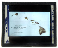 |
Map of Hawaii. The Hawaiian Islands / Hawaiian Exhibit Alaska-Yukon-Pacific-Exposition Seattle Washington 1909. 6 x 9 mm. color slide in glass mount by Chas. Beseler Co. of New York depicting the Hawaiian islands as complied by data from the Navy, Post Office, Secretary of the Interior, and the U.S. Geological Survey. Fine.
Estimated Value $75-UP.
View details and enlarged photo
| Realized
$46 |
Lot 591 |
|
Map of Sierra Lione. A Map of the Coast and Country About Sierra Lione and Sherbro River. Etching on paper. Circa 1730. Plate 177, no. 101, volume 2, pg. 386. Sheet size: 9¾ x 15". Light foxing, a small stain at the lower left in margin. Still, in good condition.
Estimated Value $150 - 200.
View details
| Realized
$92 |
Lot 592 |
|
Map of the Western Coast of Africa. A Chart of the Western Coast of Africa from the Twelfth Degree of Latitude…. Etching on paper. Circa 1738. Plate 164, no. 94, volume 2, pg. 362. Sheet size: 15 x 9¾". Light pinholes along lower edge, time staining. Otherwise, in good condition.
Near the equator, this map illustrates the west coast of Africa near the Gulf of Guinea of St. Thomas.
Estimated Value $150 - 200.
View details
| Realized
$92 |
Lot 593 |
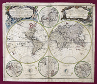 |
Mappe Monde qui represente les deux Hemispheres. Homann Heirs, 1746. Or, Planiglobii Terrestris Mappa Universalis. Nuremburg (?). Sheet size: 23 x 19¾". Image size: 21¾ x 18¼". Hand-colored, probable combination of old and newer color. Gorgeous map of the two hemispheres, with four smaller polar projections and two illustrations of solar positions. Two ornate colored cartouches -- one shows the title and publishing information in Latin, the other in French. Matted and framed to 32 x 26". One distinct vertical center fold with creasing and minor soil to either side, overall minor soil, toning and foxing is worse in margins, two top corners show minor paper loss with additional creasing and probable adhesive residue at top right, one small tear (¾") at top margin and one very small nick at lower left margin, faint 2" abrasion near the tip of Japan. Not examined out of frame. In spite of the defects mentioned above, this remains a very attractive and appealing map.
The incomplete outlines of the American West, the absence of polar land masses (with the exception of Greenland's coast), and the rudimentary description of the Australian coast emphasize the age of this map and the elaborate cartouches and projections illustrate the importance of this map at its creation, both as a tool for learning and a status symbol.
Estimated Value $600 - 700.
View details and enlarged photo
| Realized
$863 |
Lot 594 |
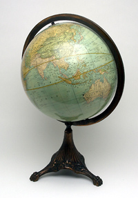 |
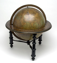
Rand McNally 12 inch Terrestrial Globe. Desk globe, twelve paper gores, varnished. Time dial at North Pole, cast bronze full ring meridian, art nouveau style tripod metal base. Oval analemma, equinoctial, colure and isothermal lines depicted, as well as ocean currents. Cartouche reads "Rand, McNally & Co.'s / New / Twelve Inch / Terrestrial / Globe". Minor cracks (with no separation) and tiny areas of lacquer loss, a few small dents, some soil and two small ink spots, else, very good condition.
A wonderful remnant of the early 20th century -- a reminder of a very different time! Indian Territory is noted in Oklahoma, the "Austro Hungaria Monarchy" sprawls across Europe and the Great Powers dominate the map of Africa -- all place this globe before the Great War changed the world's maps and so many of its people. It is this sense of nostalgia which makes antique globes so desirable in our ever-changing world.
Estimated Value $700 - 800.
View details and enlarged photo
| Realized
$403 |
Lot 595 |
 |
Schedler's 12 inch Terrestrial Globe. Desk globe, twelve paper gores, varnished. Time dial at North Pole, cast metal meridian and horizon rings, horizon ring has varnished paper label indicating zodiac and other measurements, mounted on wooden table stand with turned legs and floral design on stretchers. Legend indicates sea lanes and telegraph lines. Logo reads "H. Schedler's / Terrestrial / Globe / 12 in. Diameter… / Copyright 1889…/ Mfgd. by Robert Gair, New York" The varnish has darkened on the globe and the horizon ring, giving a definite sepia-tone to the globe, with some mottled, darker spots (very noticeable on the horizon ring). There are several sizable chips (¼ - 1¼") at various spots on the globe, scattered cracks, a few abrasions, and a handful of very minor dents. Overall, poor to fair condition.
While this globe is not in the best of condition, it makes a grand impression. The darkened varnish makes one feel as if he is journeying far, far into the past when the labels "Chinese Empire", "Beloochistan", "Hindostan" and "Anam" conjured up dreamy visions of adventure (as they do for some of us even today). The inclusion of shipping lines and telegraph wires serve to remind us of a time when trips across the ocean were measured in days, not hours, and when the cell phone was beyond the wildest imaginings.
Estimated Value $400 - 450.
View details and enlarged photo
| Realized
$518 |
Lot 596 |
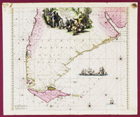 |
Tractus Australior… Map of South America, circa 1715. Tractus Australior Americae Meridionalis, a Rio de la Plata per Fretum Magellanicum ad Toraltum. Probably Renard, Amsterdam. Sheet size: 25 x 21". Image size: 21¾ x 19". Beautiful hand-colored sea chart of the tip of South America from the Rio de la Plata to Tierra del Fuego, with the Strait of Magellan and the Le Maire Strait. Large, wonderfully colored title cartouche shows indigenous peoples mining and processing gold while a group of European men observe them. A sea battle rages in the Atlantic off the coast of the Terra Magellanica and a lone vessel makes its way in the far southern ocean. Rhumb lines and compass roses add additional decoration. Framed and matted to 34 x 28". Adhesive residue and foxing very noticeable in top two corners of margin could be easily matted out, 2¼" tear at center crease, a handful of assorted nicks and small tears to outer edges, one area of water spotting in left margin, minor foxing and toning in map itself. Not examined out of frame, appears to be in very good condition.
A gorgeous piece of history.
Estimated Value $700 - 800.
View details and enlarged photo
| Realized
$661 |
|
|