
|
Sale 105
June 30 - July 1 2018 Manuscript, Space and Collectibles Sale
| Lot |
Photo |
Description |
Realized |
Lot 222 |
 |
2007 Map of Hawaii -- Ka'anapali pohaku, by William Horak -- With Lovely Traditional Hawaiian Scene. 19½ x 29¼", housed in a 29¼ x 39¼" rattan frame, which has a few scuffs. A traditional Hawaiian scene, featuring a native in a traditional Hawaiian outrigger canoe, covers the lower portion of the map. While working as a field engineer in Hawaii from 1985 to 1992, William Horak fell in love with Hawaii's culture, history, and geographic environment. The result is his unique Hawaiian maps. Estimate Value $400 - UP
View details and enlarged photo
| Unsold |
Lot 223 |
|
Withdrawn
| Unsold |
Lot 224 |
|
Withdrawn
| Unsold |
Lot 225 |
 |
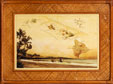
"A View of Savanah as it stood the 29th of March 1734," Drawn by Peter Gordon, Engraved by Pierre Fourdrinier. 14¾ x 17¾". Legend dedicates the map "To the Hon.ble the Trustees for establishing the Colony of Georgia in America. Thie View of the Town of Savanah is humbly dedicated by their Honours Obliged and most Obedient Servant. Peter Gordon…." The view shows a grid of streets and squares which were laid out by James Oglethorpe, founder of the colony in 1732. Ships and sailing boats are in the foreground. Matted and framed to 22¼ x 25"; light stain visible at lower far left edge of mat; a few nicks to frame. Peter Gordon was an early settler of Georgia and was its first bailiff. This is the earliest view not only of Savannah, but of any Southern city. Not from the 1735 publishing; there was a later publishing in 1876. Estimate Value $400 - UP
View details and enlarged photo
| Realized
$240 |
Lot 226 |
 |
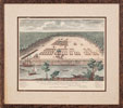
Bowles's New Pocket Map of Jamaica Divided into its Parishes, &c -- (1792). London, Printed for the Proprietor Carrington Bowles, 20 x 22¾", matted and framed to 24¼ x 27¼"; a few scuffs to frame. Map dividing Jamaica into its parishes, towns, and major settlements. With a large inset of Port Royal at lower left, and a lovely wind rose. Light toning, else fine. Estimate Value $250 - UP
View details and enlarged photo
| Unsold |
Lot 227 |
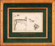 |
Chart of the Sandwich Isles : Sketch of Karakakooa Bay, c. 1790 -- Early Map of the Hawaiian Islands Tracking Capt. Cook's Voyages. "Accurately Engraved for Anderson's Large Folio Edition of the Whole of Captn. Cook's Voyages &c Complete." London. Published by Alexander Hogg at the Kings Arms, No. 16, Paternoster Row, engraved by T. Conder. 8¾ x 14". Copper engraving of the Hawaiian Islands with Cook's tracks shown, and an inset map of Karakakooa Bay marked, "Here Capt. Cook was killed". Beautifully matted and framed to an overall size of 21 x 25". A lovely display item. Estimate Value $400 - UP
View details and enlarged photo
| Unsold |
Lot 228 |
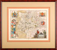 |
Premium British County Map Hvntingdonensis Comitatvs. Huntington Shire, Blaeu, 1646. British County map, 15½ x 19¾, matted and framed to an overall size of 27 x 30¼".Cartouche of two hunters with their dogs, their hawk and the animals they have bagged. With decorative royal coats of arms; at left, putti link with ribbons coats of arms belonging to prominent people. Various landmarks--structures, forests, hills, etc. are noted. Very attractive. Estimate Value $500 - UP
View details and enlarged photo
| Realized
$320 |
|
|